
Mapa topográfico Caistor
Clique no mapa para exibir a altitude.
Sobre este mapa
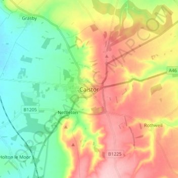
Nome: Mapa topográfico Caistor, altitude, relevo.
Altitude média: 80 m
Altitude mínima: 13 m
Altitude máxima: 166 m
Outros mapas topográficos
Clique em um mapa para visualizar sua topografia, sua altitude e seu relevo.
Welton CP
United Kingdom > England > Lincolnshire > West Lindsey
The parish stretches from the ancient Ermine Street (A15) in the west, following a north-easterly shape to the Barlings Eau at its eastern end, of which the Welton Beck is a tributary, and is an example of a strip parish. Due to the low, flat topography of Lincolnshire, land had to be drained for agriculture…
Altitude média: 27 m
North Willingham CP
United Kingdom > England > Lincolnshire > West Lindsey > North Willingham CP
Altitude média: 82 m
Corringham CP
United Kingdom > England > Lincolnshire > West Lindsey > Corringham CP
Altitude média: 21 m