
Faça uma doação
Mapa topográfico Ungaran
Clique no mapa para exibir a altitude.
Faça uma doação
Ungaran
Ungaran (Dutch: Oengaran) is a town and adjacent areas in Central Java Province of Indonesia. The town serves as the administrative centre of the Semarang Regency in that province. Ungaran is located at -7° 8' 17", 110° 24' 18" at an elevation of 319 metres. It encompasses two districts (kecamatan) within the Regency - Ungaran Barat (West Ungaran) covering 35.96 km2 with a population of 82,815 in 2024, and Ungaran Timur (East Ungaran) covering 37.99 km2 with a population of 83,610 in 2024.
Faça uma doação
Sobre este mapa
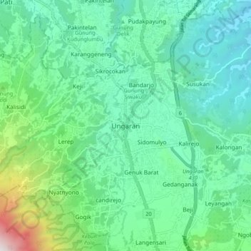
Nome: Mapa topográfico Ungaran, altitude, relevo.
Altitude média: 399 m
Altitude mínima: 78 m
Altitude máxima: 1.558 m
Faça uma doação
Outros mapas topográficos
Clique em um mapa para visualizar sua topografia, sua altitude e seu relevo.
Alun-Alun Ambarawa
Indonesia > Central Java > Kabupaten Semarang > Tambakboyo > Katang
Altitude média: 499 m