
Faça uma doação
Mapa topográfico Aniakchak National Monument
Clique no mapa para exibir a altitude.
Faça uma doação
Aniakchak National Monument
The national monument is centered on the 6-mile (9.7 km) diameter crater of ancient Mount Aniakchak, which was destroyed and the resulting crater formed during a caldera collapse event about 3,700 years ago. The original mountain, about 7,000 feet (2,100 m) tall, collapsed into its magma chamber, leaving an approximate 3,300-foot (1,000 m) deep summit crater. (The elevation of the high point on the crater rim, Aniakchak Peak, is approximately 4,380 feet. The elevation of the low point of the caldera floor, at the mouth of Surprise Lake and the beginning of the Aniakchak River, is approximately 1,055 feet.) The monument and surrounding preserve include the volcanic feature, the wild Aniakchak River, the Bristol Bay coastal habitat, and portions of the coast of the Pacific Ocean.
Faça uma doação
Sobre este mapa
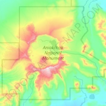
Nome: Mapa topográfico Aniakchak National Monument, altitude, relevo.
Altitude média: 376 m
Altitude mínima: 31 m
Altitude máxima: 1.321 m
Faça uma doação
Outros mapas topográficos
Clique em um mapa para visualizar sua topografia, sua altitude e seu relevo.