
Faça uma doação
Mapa topográfico Sestao
Clique no mapa para exibir a altitude.
Faça uma doação
Sestao
The growth of the town of Sestao is limited by the lack of developable land and severely limited by natural and artificial barriers. For this reason, it has reached a highly densified town with a network of small open spaces. Historically, The grew of the population was a consequence of the development of the industry, and not the industry a consequence of the human presence in the area. This defines the DNA of Sestao. It is a settlement that is born exclusively by the implantation of the heavy industry. Consumption and land distribution is based on the industry (now there is more floor dedicated to industrial than residential uses) and these industrial areas are located in the best situations the city. The margin facing the estuary is colonized exclusively for industry, and the least quality areas (up to sixty meters of altitude) is intended to construction of workers' housing.
Faça uma doação
Sobre este mapa
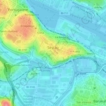
Nome: Mapa topográfico Sestao, altitude, relevo.
Altitude média: 21 m
Altitude mínima: -3 m
Altitude máxima: 94 m
Faça uma doação
Outros mapas topográficos
Clique em um mapa para visualizar sua topografia, sua altitude e seu relevo.
Hondarribiko hondartza
Spain > Autonomous Community of the Basque Country > Gipuzkoako Bidasoa > Hondarribia
Altitude média: 31 m
Faça uma doação
Karakate
Spain > Autonomous Community of the Basque Country > Debabarrena > Soraluze
Altitude média: 366 m
Gebara
Spain > Autonomous Community of the Basque Country > Arabako lautada/Llanada Alavesa
Altitude média: 574 m
Faça uma doação
Makola
Spain > Autonomous Community of the Basque Country > Urola-Kosta > Azkoitia
Altitude média: 515 m
Gorbeia
Spain > Autonomous Community of the Basque Country > Gorbeialdea > Zeanuri
Altitude média: 1.189 m
Faça uma doação
Santa Barbara
Spain > Autonomous Community of the Basque Country > Hernani > Sorgintxulo
Altitude média: 68 m
Bujal
Spain > Autonomous Community of the Basque Country > Añanako kuadrilla > Berantevilla
Altitude média: 535 m
Araneta
Spain > Autonomous Community of the Basque Country > Gasteizko kuadrilla/Cuadrilla de Vitoria > Vitoria-Gasteiz > Bolívar
Altitude média: 625 m
Faça uma doação
Soil
Spain > Autonomous Community of the Basque Country > Montaña Alavesa/Arabako Mendialdea
Altitude média: 898 m
Fuente Oneri
Spain > Autonomous Community of the Basque Country > Arabako lautada/Llanada Alavesa > Agurain/Salvatierra
Altitude média: 681 m
Faça uma doação
Barinatxe - La Salvaje
Spain > Autonomous Community of the Basque Country > Sopela
Altitude média: 26 m
Lore-Toki
Spain > Autonomous Community of the Basque Country > Arabako Errioxa/Rioja Alavesa > Labastida/Bastida
Altitude média: 499 m
Faça uma doação
Trevilla
Spain > Autonomous Community of the Basque Country > Karrantza Harana/Valle de Carranza > Concha
Altitude média: 333 m
Faça uma doação
Floreaga
Spain > Autonomous Community of the Basque Country > Urola-Kosta > Azkoitia
Altitude média: 266 m
Monterredondo
Spain > Autonomous Community of the Basque Country > Añanako kuadrilla/Cuadrilla de Añana
Altitude média: 875 m
Faça uma doação
Faça uma doação
Gautegiz Arteaga
Spain > Autonomous Community of the Basque Country > Gautegiz Arteaga > Gautegiz Arteaga
Altitude média: 104 m
Zaldibar
Spain > Autonomous Community of the Basque Country > Zaldibar > Zaldibar
Altitude média: 305 m
Soil
Spain > Autonomous Community of the Basque Country > Montaña Alavesa/Arabako Mendialdea
Altitude média: 898 m