
Obrigado por apoiar este site ❤️
Faça uma doação
Faça uma doação
Mapa topográfico Palestine
Clique no mapa para exibir a altitude.
Obrigado por apoiar este site ❤️
Faça uma doação
Faça uma doação
Palestine
About 40% of the content from the 2003 Space Shuttle Columbia disaster was recovered, seven astronauts were killed in the accident. Debris from Columbia was found in and outside Palestine and other East Texas towns. Palestine's NASA Columbia Scientific Balloon Facility (renamed in honor of the shuttle crew), has flown 1,700 high-altitude balloons for universities and research agencies.
Obrigado por apoiar este site ❤️
Faça uma doação
Faça uma doação
Sobre este mapa
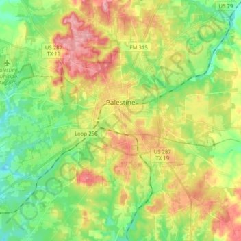
Nome: Mapa topográfico Palestine, altitude, relevo.
Local: Palestine, Anderson County, Texas, United States (31.69527 -95.72426 31.80843 -95.56776)
Altitude média: 136 m
Altitude mínima: 85 m
Altitude máxima: 204 m
Obrigado por apoiar este site ❤️
Faça uma doação
Faça uma doação
Outros mapas topográficos
Clique em um mapa para visualizar sua topografia, sua altitude e seu relevo.