
Faça uma doação
Mapa topográfico Cabo Corrientes
Clique no mapa para exibir a altitude.
Faça uma doação
Cabo Corrientes
Cabo Corrientes is in the west of the state, on the Pacific Ocean. Elevations range from sea level to 1,085 metres (3,560 ft). The Bahía de Banderas is to the north, Puerto Vallarta to the northeast, Talpa de Allende to the east, Tomatlán to the south, and the Pacific Ocean to the west.
Faça uma doação
Sobre este mapa
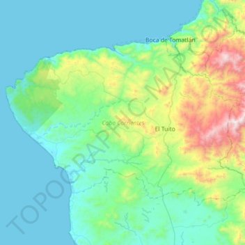
Nome: Mapa topográfico Cabo Corrientes, altitude, relevo.
Local: Cabo Corrientes, Jalisco, Mexico (20.15317 -105.69540 20.51305 -105.13109)
Altitude média: 348 m
Altitude mínima: -1 m
Altitude máxima: 2.058 m
Faça uma doação
Outros mapas topográficos
Clique em um mapa para visualizar sua topografia, sua altitude e seu relevo.
Ajijic
The Chapala Lake basin has a year-round average temperature of about 19 °C (66 °F). Due to Ajijic's tropical latitude and relatively high elevation, it is seldom unpleasantly hot or humid. The rainy season begins in June and lasts until October. The average rainfall is 793 millimetres (31.2 in). Even during…
Altitude média: 1.738 m
Faça uma doação
Tequila
Tequila is one of the 124 municipalities of Jalisco, located just west of the center of the state. Its territory extends for 1689.11km2, with elevations that vary between 700 and 2,900 meters above sea level. The municipality borders with the main metropolitan region of Guadalajara to the east (Zapopan), and…
Altitude média: 1.267 m
Faça uma doação
Faça uma doação
Faça uma doação
Capilla de Guadalupe
Mexico > Jalisco > Tepatitlán de Morelos > Capilla de Guadalupe
Altitude média: 2.049 m
Faça uma doação