
Mapa topográfico Red Lake County
Mapa interativo
Clique no mapa para exibir a altitude.
Sobre este mapa
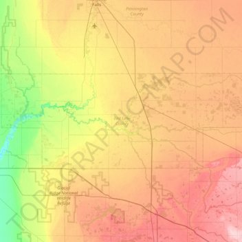
Nome: Mapa topográfico Red Lake County, altitude, relevo.
Local: Red Lake County, Minnesota, United States of America (47.76030 -96.48460 47.96593 -95.71173)
Altitude média: 341 m
Altitude mínima: 268 m
Altitude máxima: 420 m
The Red Lake River flows southward into the county from Pennington. It is joined near Red Lake Falls by the Clearwater River; the combined flow (still known as the Red Lake River) flows southwestward to Huot, where it is augmented by the Black River which drains the NW part of the county. The Red Lake River then flows southwestward into Polk County. The county terrain consists of low rolling hills, etched by drainages and gullies. The area is devoted to agriculture. The county terrain slopes to the west, with its highest elevation on its SE corner, at 1,201' (366m) ASL. The county has a total area of 432 square miles (1,120 km2), of which 432 square miles (1,120 km2) is land and 0.09 square miles (0.23 km2) (0.02%) is water.
Outros mapas topográficos
Clique em um mapa para visualizar sua topografia, sua altitude e seu relevo.
Brooklyn Park
United States of America > Minnesota > Brooklyn Park
Brooklyn Park, Hennepin County, Minnesota, United States of America
Altitude média: 265 m
Stevens County
United States of America > Minnesota
Stevens County, Minnesota, United States of America
Altitude média: 345 m
Todd County
United States of America > Minnesota
Todd County, Minnesota, United States of America
Altitude média: 403 m
Farmington
United States of America > Minnesota > Farmington
Farmington, Dakota County, Minnesota, 55024, United States of America
Altitude média: 280 m
Fairmont
United States of America > Minnesota > Fairmont
Fairmont, Martin County, Minnesota, 56031, United States of America
Altitude média: 361 m
Apple Valley
United States of America > Minnesota > Apple Valley
Apple Valley, Dakota County, Minnesota, 55124, United States of America
Altitude média: 301 m
Greenbush
United States of America > Minnesota > Greenbush
Greenbush, Roseau County, Minnesota, 56726, United States of America
Altitude média: 324 m
Lake Itasca
United States of America > Minnesota > Lake Itasca
Lake Itasca, Clearwater County, Minnesota, 56480, United States of America
Altitude média: 460 m
Beaver Creek
United States of America > Minnesota > Beaver Creek
Beaver Creek, Rock County, Minnesota, 56116, United States of America
Altitude média: 447 m
Brownton
United States of America > Minnesota > Brownton
Brownton, McLeod County, Minnesota, United States of America
Altitude média: 314 m
Birchmont
United States of America > Minnesota > Birchmont
Birchmont, Beltrami County, Minnesota, 56601, United States of America
Altitude média: 419 m
Erskine
United States of America > Minnesota > Erskine
Erskine, Polk County, Minnesota, United States of America
Altitude média: 365 m
Etna Creek
United States of America > Minnesota
Etna Creek, Fillmore County, Minnesota, United States of America
Altitude média: 404 m
Watson
United States of America > Minnesota > Watson
Watson, Chippewa County, Minnesota, United States of America
Altitude média: 305 m
Maple Grove
United States of America > Minnesota > Maple Grove
Maple Grove, Hennepin County, Minnesota, United States of America
Altitude média: 280 m
New Ulm
United States of America > Minnesota > New Ulm
New Ulm, Brown County, Minnesota, 56073, United States of America
Altitude média: 278 m