
Mapa topográfico Lake Waco
Mapa interativo
Clique no mapa para exibir a altitude.
Sobre este mapa
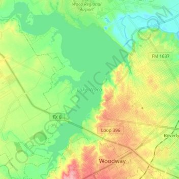
Nome: Mapa topográfico Lake Waco, altitude, relevo.
Local: Lake Waco, Waco, McLennan County, Texas, United States (31.49404 -97.29888 31.61117 -97.18973)
Altitude média: 157 m
Altitude mínima: 118 m
Altitude máxima: 223 m
The average elevation of Lake Waco is held around 460 feet above sea level, with a typical fluctuation of 2–6 feet. Prior to the construction of the new dam, droughts and floods were common occurrences for the city of Waco. However, the new dam has proven to be the proper solution, as there has not been any serious floods since its installation. However, a 2011 study from the Texas Water Development Board found that Lake Waco loses between 206-334 acre-feet of capacity every year due to sediment deposition.
Outros mapas topográficos
Clique em um mapa para visualizar sua topografia, sua altitude e seu relevo.
Speegleville
United States > Texas > McLennan County > Waco
Speegleville, Waco, McLennan County, Texas, 76712, United States
Altitude média: 151 m
Waco
United States > Texas > McLennan County > Waco
Waco, McLennan County, Texas, 76701, United States
Altitude média: 150 m
Bosqueville
United States > Texas > McLennan County > Waco > Bosqueville
Bosqueville, Waco, McLennan County, Texas, 76708, United States
Altitude média: 135 m