
Faça uma doação
Mapa topográfico Outeiro de Rei
Clique no mapa para exibir a altitude.
Faça uma doação
Outeiro de Rei
The town lies on a hill surrounded by the rivers Miño, Rato and Chanca. The difference in altitude between the city centre and the river banks is considerable: the former being at an altitude of 465 meters above sea level, whilst the Miño River Walk is at an altitude of only 364 metres (1,194 feet). The municipality of Lugo is the second largest in Galicia, with 329.78 square kilometres (127.33 sq mi) and 59 parishes. The outline of the city was declared a Biosphere Reserve by UNESCO on 7 November 2002, this being the most important recognition at international level regarding the conservation of landscapes and habitats of this Atlantic European region.
Faça uma doação
Sobre este mapa
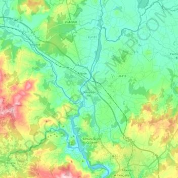
Nome: Mapa topográfico Outeiro de Rei, altitude, relevo.
Local: Outeiro de Rei, Lugo, Galicia, Spain (43.04711 -7.72654 43.16662 -7.49073)
Altitude média: 443 m
Altitude mínima: 367 m
Altitude máxima: 634 m
Faça uma doação
Outros mapas topográficos
Clique em um mapa para visualizar sua topografia, sua altitude e seu relevo.