
Faça uma doação
Mapa topográfico Shawell
Clique no mapa para exibir a altitude.
Faça uma doação
Sobre este mapa
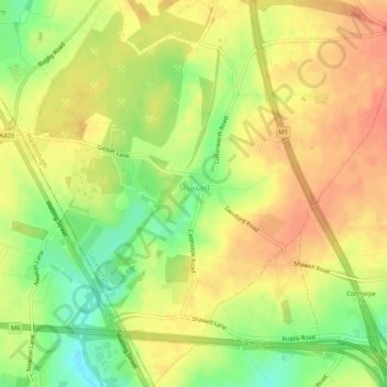
Nome: Mapa topográfico Shawell, altitude, relevo.
Local: Shawell, Leicestershire, England, United Kingdom (52.40187 -1.22362 52.43262 -1.17308)
Altitude média: 127 m
Altitude mínima: 98 m
Altitude máxima: 145 m
Faça uma doação
Outros mapas topográficos
Clique em um mapa para visualizar sua topografia, sua altitude e seu relevo.
Bottesford
United Kingdom > England > Leicestershire > Melton
Bottesford's many listed buildings include the grade I listed 13th-century Church of St Mary the Virgin. There are two scheduled monuments within the village – Fleming's Bridge and the stone cross in the Market Place. The stocks and whipping post are Grade II listed. One of the Grade II listed buildings,…
Altitude média: 39 m
Faça uma doação
Faça uma doação
Faça uma doação
Faça uma doação
Faça uma doação
Isley Walton
United Kingdom > England > Leicestershire > North West Leicestershire
Altitude média: 76 m
Markfield
United Kingdom > England > Leicestershire > Hinckley and Bosworth > Markfield
Altitude média: 174 m
Faça uma doação
Castle Donington
United Kingdom > England > Leicestershire > North West Leicestershire > Hemington
Altitude média: 56 m
Faça uma doação
Ratcliffe Culey
United Kingdom > England > Leicestershire > Hinckley and Bosworth
Altitude média: 77 m
Faça uma doação
South Croxton
United Kingdom > England > Leicestershire > Charnwood > South Croxton
The highest point is the church, at 120 m above mean sea level. The lowest altitude is 85 m by the Queniborough Brook.
Altitude média: 108 m
Thringstone
United Kingdom > England > Leicestershire > North West Leicestershire
Altitude média: 126 m
Faça uma doação
Swannington
United Kingdom > England > Leicestershire > North West Leicestershire > Coalville
Altitude média: 132 m
Faça uma doação
Ashby-de-la-Zouch
United Kingdom > England > Leicestershire > North West Leicestershire
Altitude média: 132 m
Queniborough
United Kingdom > England > Leicestershire > Charnwood > Queniborough
Altitude média: 75 m
Faça uma doação
Faça uma doação
Illston on the Hill
United Kingdom > England > Leicestershire > Harborough > Illston on the Hill
Altitude média: 158 m
Faça uma doação
Faça uma doação
Stretton Baskerville
United Kingdom > England > Leicestershire > Hinckley and Bosworth
Altitude média: 111 m
Faça uma doação
Leicester Forest East
United Kingdom > England > Leicestershire > Leicester Forest East
Altitude média: 96 m
Breedon on the Hill
United Kingdom > England > Leicestershire > North West Leicestershire
Altitude média: 84 m
South Kilworth
United Kingdom > England > Leicestershire > Harborough > South Kilworth
Altitude média: 134 m
Faça uma doação
Leicestershire
United Kingdom > England > Leicestershire
A large part of the north-west of the county, around Coalville, forms part of the new National Forest area extending into Derbyshire and Staffordshire. The highest point of the county is Bardon Hill at 278 m (912 ft), which is also a Marilyn; with other hilly/upland areas of c. 150–200 metres (490–660 ft)…
Altitude média: 98 m
Newbold Verdon
United Kingdom > England > Leicestershire > Hinckley and Bosworth
Altitude média: 129 m
Faça uma doação
Burbage
United Kingdom > England > Leicestershire > Hinckley and Bosworth > Stretton Baskerville
Altitude média: 110 m
Broughton Astley
United Kingdom > England > Leicestershire > Harborough > Broughton Astley
Altitude média: 87 m
Faça uma doação
Ravenstone
United Kingdom > England > Leicestershire > North West Leicestershire
Altitude média: 143 m
Faça uma doação
Long Whatton
United Kingdom > England > Leicestershire > North West Leicestershire
Altitude média: 63 m
Barton in the Beans
United Kingdom > England > Leicestershire > Hinckley and Bosworth
Altitude média: 113 m
Higham on the Hill
United Kingdom > England > Leicestershire > Hinckley and Bosworth
Altitude média: 96 m
Timberwood Hill
United Kingdom > England > Leicestershire > North West Leicestershire
Altitude média: 192 m
Faça uma doação
Faça uma doação
Faça uma doação
Thornton Reservoir
United Kingdom > England > Leicestershire > Hinckley and Bosworth > Thornton
Altitude média: 139 m
Faça uma doação
Merry Lees
United Kingdom > England > Leicestershire > Hinckley and Bosworth > Botcheston
Altitude média: 126 m
Kilby Bridge
United Kingdom > England > Leicestershire > Oadby and Wigston > Wigston
Altitude média: 89 m
Belvoir Castle
United Kingdom > England > Leicestershire > Melton > Belvoir
The traditional burial place of the Manners family was St Mary the Virgin's Church, Bottesford. Since elevation to the dukedom in 1703 most Dukes have been buried in the grounds of the mausoleum at Belvoir Castle. The mausoleum at Belvoir Castle was built by The 5th Duke of Rutland, following the death of his…
Altitude média: 82 m
Faça uma doação
Faça uma doação