Geolocalizar

Mapa topográfico Sharpness

Clique no mapa para exibir a altitude.

Sobre este mapa

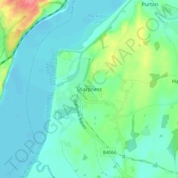
Nome: Mapa topográfico Sharpness, altitude, relevo.

Local: Sharpness, Stroud, Gloucestershire, England, GL13 9PE, United Kingdom (51.69663 -2.49073 51.73663 -2.45073)

Altitude média: 17 m

Altitude mínima: -1 m

Altitude máxima: 75 m

Outros mapas topográficos

Clique em um mapa para visualizar sua topografia, sua altitude e seu relevo.

Pitchcombe

United Kingdom > England > Gloucestershire > Stroud

Altitude média: 146 m

Arlingham

United Kingdom > England > Gloucestershire > Stroud

Altitude média: 14 m

Kingswood

United Kingdom > England > Gloucestershire > Stroud

Altitude média: 65 m

Cranham

United Kingdom > England > Gloucestershire > Stroud

Altitude média: 196 m

Chalford

United Kingdom > England > Gloucestershire > Stroud > Chalford

Altitude média: 170 m

Uley

United Kingdom > England > Gloucestershire > Stroud

Altitude média: 140 m

Alderley

United Kingdom > England > Gloucestershire > Stroud

In A Topographical Dictionary of England by Samuel Lewis published in 1831, Alderley is described thus.

Altitude média: 95 m

Cam

United Kingdom > England > Gloucestershire > Stroud > Cam

Altitude média: 69 m