
Mapa topográfico Modasa
Mapa interativo
Clique no mapa para exibir a altitude.
Modasa
Modasa is located at 23°28′N 73°18′E / 23.47°N 73.3°E / 23.47; 73.3. It has an average elevation of 197 metres (646 feet). Most of the water for Modasa comes from the Mazum river, on which, about 5 kilometers from Modasa, the Mazum reservoir is situated.
Sobre este mapa
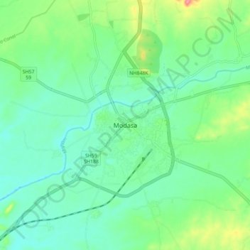
Nome: Mapa topográfico Modasa, altitude, relevo.
Local: Modasa, Modasa Taluka, Aravalli, Gujarat, 383315, India (23.42342 73.25906 23.50342 73.33906)
Altitude média: 149 m
Altitude mínima: 125 m
Altitude máxima: 211 m