
Mapa topográfico Fingal
Mapa interativo
Clique no mapa para exibir a altitude.
Sobre este mapa
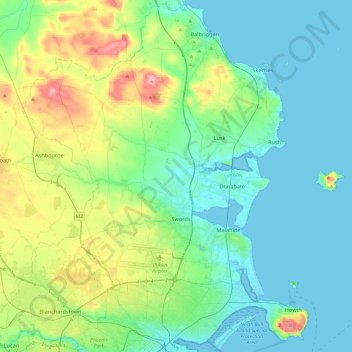
Nome: Mapa topográfico Fingal, altitude, relevo.
Local: Fingal, County Dublin, Leinster, Ireland (53.35349 -6.47504 53.63471 -5.99450)
Altitude média: 39 m
Altitude mínima: -1 m
Altitude máxima: 175 m
Outros mapas topográficos
Clique em um mapa para visualizar sua topografia, sua altitude e seu relevo.
Finglas East
Ireland > County Dublin > Dublin
Finglas East, Finglas, Ballygall A ED, Dublin, County Dublin, Leinster, Ireland
Altitude média: 57 m
Dublin (Finglas)
Ireland > County Dublin > Dublin
Dublin (Finglas), Dublin, Fingal, County Dublin, Leinster, Ireland
Altitude média: 48 m
Sandymount
Ireland > County Dublin > Dublin
Sandymount, Pembroke East C ED, Dublin, County Dublin, Leinster, Ireland
Altitude média: 5 m
Corballis
Corballis, Donabate DED 1986, Fingal, County Dublin, Leinster, Ireland
Altitude média: 3 m
Donabate
Donabate, Semple Woods, Donabate DED 1986, Fingal, County Dublin, Leinster, Ireland
Altitude média: 6 m
Ballybrack
Ireland > County Dublin > Killiney
Ballybrack, Killiney North DED 1986, Killiney, Dún Laoghaire-Rathdown, County Dublin, Leinster, Ireland
Altitude média: 32 m
Brenanstown
Brenanstown, Dún Laoghaire-Rathdown, County Dublin, Leinster, Ireland
Altitude média: 62 m
Sutton
Sutton, Fingal, County Dublin, Leinster, D13 A7X4, Ireland
Altitude média: 8 m
Cornelscourt
Cornelscourt, Dún Laoghaire-Rathdown, County Dublin, Leinster, D18 TD00, Ireland
Altitude média: 59 m
Booterstown, Blackrock and Dundrum Parish
Ireland > County Dublin > Goatstown
Booterstown, Blackrock and Dundrum Parish, Goatstown, Dún Laoghaire-Rathdown, County Dublin, Leinster, Ireland
Altitude média: 86 m
Portmarnock
Portmarnock, Fingal, County Dublin, Leinster, Ireland
Altitude média: 6 m
Balbriggan
Balbriggan, Fingal, County Dublin, Leinster, Ireland
Altitude média: 22 m
Dublin North City Poor Law Union
Dublin North City Poor Law Union, County Dublin, Leinster, Ireland
Altitude média: 38 m
Shanganhill
Shanganhill, Dubber ED, Fingal, County Dublin, Leinster, Ireland
Altitude média: 77 m
Clonsilla
Clonsilla, Fingal, County Dublin, Leinster, D15 T0HE, Ireland
Altitude média: 59 m
Crumlin
Ireland > County Dublin > Dublin
Crumlin, Walkinstown C ED, Dublin, County Dublin, Leinster, Ireland
Altitude média: 43 m
Tallaght
Ireland > County Dublin > Tallaght
Tallaght, South Dublin, County Dublin, Leinster, D24 T99C, Ireland
Altitude média: 121 m
Lucan
Ireland > County Dublin > Lucan
Lucan, South Dublin, County Dublin, Leinster, K78 Y0F1, Ireland
Altitude média: 59 m
Dún Laoghaire-Rathdown
Dún Laoghaire-Rathdown, County Dublin, Leinster, Ireland
Altitude média: 139 m
Swords
Ireland > County Dublin > Swords
Swords, Fingal, County Dublin, Leinster, K67 X8Y2, Ireland
Altitude média: 28 m
Ballymount
Ireland > County Dublin > Clondalkin
Ballymount, Ballymount Great, Clondalkin-Ballymount ED, Clondalkin, South Dublin, County Dublin, Leinster, D22 R3H2, Ireland
Altitude média: 68 m
Belcamp
Ireland > County Dublin > Dublin
Belcamp, Priorswood B ED, Dublin, County Dublin, Leinster, Ireland
Altitude média: 37 m
Mountmerrion or Callary
Ireland > County Dublin > Dundrum
Mountmerrion or Callary, Stillorgan-Deerpark DED 1986, Dundrum, Dún Laoghaire-Rathdown, County Dublin, Leinster, Ireland
Altitude média: 44 m
Loughlinstown River, North
Loughlinstown River, North, Loughlinstown, Killiney South ED, Dún Laoghaire-Rathdown, County Dublin, Leinster, D18 KP65, Ireland
Altitude média: 36 m
Palmerstown
Ireland > County Dublin > Palmerstown
Palmerstown, South Dublin, County Dublin, Leinster, D20 DC99, Ireland
Altitude média: 51 m
Crowscastle
Crowscastle, Swords ED, Fingal, County Dublin, Leinster, K67 R8W3, Ireland
Altitude média: 35 m
Dún Laoghaire
Dún Laoghaire, Dún Laoghaire-Rathdown, County Dublin, Leinster, A96 T860, Ireland
Altitude média: 21 m
Barberstown
Barberstown, Dubber ED, Fingal, County Dublin, Leinster, Ireland
Altitude média: 68 m
14
Ireland > County Dublin > Blackrock
14, The Stables, Mount Merrion, Mountmerrion or Callary, Stillorgan-Mount Merrion ED, Blackrock, Dún Laoghaire-Rathdown, County Dublin, Leinster, A94 EK75, Ireland
Altitude média: 48 m
Blanchardstown
Blanchardstown, Fingal, County Dublin, Leinster, D15 KPW7, Ireland
Altitude média: 61 m
Balbriggan
Ireland > County Dublin > Balbriggan
Balbriggan, Fingal, County Dublin, Leinster, K32 R282, Ireland
Altitude média: 25 m
Dundrum
Dundrum, Dún Laoghaire-Rathdown, County Dublin, Leinster, D14 V9R3, Ireland
Altitude média: 79 m
Rathfarnham
Rathfarnham, South Dublin, Dublin 14, Leinster, D14 K3T6, Ireland
Altitude média: 56 m
Rathfarnham
Ireland > County Dublin > Rathfarnham
Rathfarnham, Churchtown-Castle DED 1986, Rathfarnham, Dún Laoghaire-Rathdown, County Dublin, Leinster, Ireland
Altitude média: 56 m
Malahide
Ireland > County Dublin > Malahide
Malahide, Fingal, County Dublin, Leinster, K36 HN84, Ireland
Altitude média: 10 m
Stepaside
Stepaside, Dún Laoghaire-Rathdown, County Dublin, Leinster, D18 YR68, Ireland
Altitude média: 183 m
North Bull Island
Ireland > County Dublin > Dublin
North Bull Island, Raheny B ED, Dublin, County Dublin, Leinster, Ireland
Altitude média: 2 m
Blackrock
Blackrock, Dún Laoghaire-Rathdown, County Dublin, Leinster, A94 VP03, Ireland
Altitude média: 30 m