
Mapa topográfico Dehradun
Mapa interativo
Clique no mapa para exibir a altitude.
Dehradun
The city of Dehradun mainly lies in Doon Valley and is at a varying height from 410 m in Clement Town to above 700 m at Malsi which is 15 km from the city. However, the average elevation is 450 m above sea level. Malsi is the starting point of Lesser Himalayan Range that extends to Mussoorie and beyond. Jaunsar-Bawar hills in Dehradun district rises to 3700m above sea level. The hilly region of Mussoorie goes up to a height of 1870–2017 metres above sea level.
Sobre este mapa
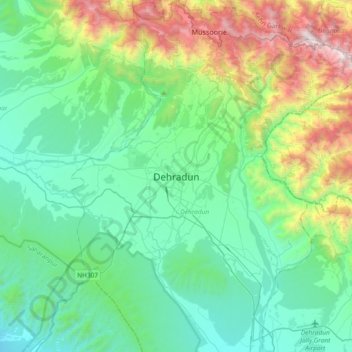
Nome: Mapa topográfico Dehradun, altitude, relevo.
Local: Dehradun, Uttarakhand, 248001, India (30.16556 77.88368 30.48556 78.20368)
Altitude média: 904 m
Altitude mínima: 402 m
Altitude máxima: 2.568 m