
Faça uma doação
Mapa topográfico Dellach
Clique no mapa para exibir a altitude.
Faça uma doação
Dellach
The municipal area lies in the upper Gail valley, between the neighbouring municipalities of Kötschach-Mauthen in the west and Kirchbach in the east. The Carnic Alps in the south form the border with Paularo in Italy. In the north rises Mt. Reißkofel, the highest peak of the Gailtal Alps east of the Lienz Dolomites, with an elevation of 2,371 metres (7,779 ft).
Faça uma doação
Sobre este mapa
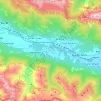
Nome: Mapa topográfico Dellach, altitude, relevo.
Local: Dellach, Bezirk Hermagor, Carinthia, 9635, Austria (46.59892 13.03389 46.70196 13.11945)
Altitude média: 1.233 m
Altitude mínima: 619 m
Altitude máxima: 2.355 m
Faça uma doação
Outros mapas topográficos
Clique em um mapa para visualizar sua topografia, sua altitude e seu relevo.
Obermöschach
Austria > Carinthia > Bezirk Hermagor > Hermagor-Pressegger See > Hermagor
Altitude média: 765 m
Faça uma doação
Lake Pressegg
Austria > Carinthia > Bezirk Hermagor > Hermagor-Pressegger See > Presseggersee > Paßriach
Altitude média: 627 m
Nassfeldpass / Passo di Pramollo
Austria > Carinthia > Bezirk Hermagor > Hermagor-Pressegger See > Sonnenalpe Naßfeld
Altitude média: 1.572 m
Faça uma doação