
Mapa topográfico Banská Bystrica
Mapa interativo
Clique no mapa para exibir a altitude.
Sobre este mapa
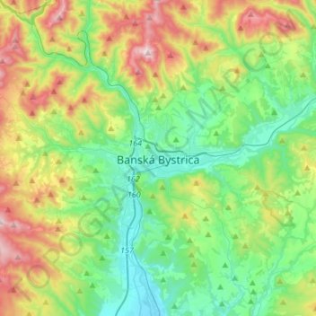
Nome: Mapa topográfico Banská Bystrica, altitude, relevo.
Altitude média: 566 m
Altitude mínima: 309 m
Altitude máxima: 1.140 m
Banská Bystrica lies at an altitude of 362 metres (1,188 ft) above sea level and covers an area of 103.37 square kilometres (39.9 sq mi). It is about halfway between Slovakia's two largest cities, 208 kilometres (129 mi) north-east from Slovakia's capital Bratislava and 217 kilometres (135 mi) west of Košice. A chain of discrete suburbs and villages connects it with Zvolen, another major town 20 kilometres (12 mi) to the south.
Outros mapas topográficos
Clique em um mapa para visualizar sua topografia, sua altitude e seu relevo.
Minca
Slovakia > Region of Banská Bystrica > District of Banská Bystrica > Strelníky
Minca, Strelníky, District of Banská Bystrica, Region of Banská Bystrica, Central Slovakia, 976 37, Slovakia
Altitude média: 892 m
Badínsky prales
Slovakia > Region of Banská Bystrica > District of Banská Bystrica > Badín
Badínsky prales, Badín, District of Banská Bystrica, Region of Banská Bystrica, Central Slovakia, Slovakia
Altitude média: 833 m
Japeň
Slovakia > Region of Banská Bystrica > District of Banská Bystrica > Dolný Harmanec
Japeň, Dolný Harmanec, District of Banská Bystrica, Region of Banská Bystrica, Central Slovakia, 976 03, Slovakia
Altitude média: 745 m