
Mapa topográfico 2nd district
Mapa interativo
Clique no mapa para exibir a altitude.
Sobre este mapa
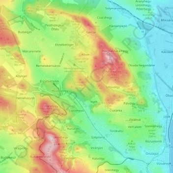
Nome: Mapa topográfico 2nd district, altitude, relevo.
Local: 2nd district, Budapest, Central Hungary, Hungary (47.50607 18.92511 47.57891 19.04271)
Altitude média: 252 m
Altitude mínima: 100 m
Altitude máxima: 513 m
Outros mapas topográficos
Clique em um mapa para visualizar sua topografia, sua altitude e seu relevo.
Békásmegyer
Békásmegyer, 3rd district, Budapest, Central Hungary, Hungary
Altitude média: 127 m
18th district
18th district, Budapest, Central Hungary, Hungary
Altitude média: 127 m
14th district
14th district, Budapest, Central Hungary, Hungary
Altitude média: 116 m
11th district
11th district, Budapest, Central Hungary, Hungary
Altitude média: 139 m
22nd district
22nd district, Budapest, Central Hungary, Hungary
Altitude média: 126 m
21st district
21st district, Budapest, Central Hungary, Hungary
Altitude média: 110 m
Gellért Hill
Gellért Hill, Budapest, V. kerület, Central Hungary, 1114, Hungary
Altitude média: 126 m
Angyalföld
Angyalföld, 13th district, Budapest, Central Hungary, Hungary
Altitude média: 110 m
17th district
17th district, Budapest, Central Hungary, Hungary
Altitude média: 159 m
Margaret Island
Margaret Island, Budapest, Central Hungary, 1007, Hungary
Altitude média: 115 m
Nagytétény
Nagytétény, 22nd district, Budapest, Central Hungary, Hungary
Altitude média: 127 m
Margaret Island
Margaret Island, Budapest, Central Hungary, 1007, Hungary
Altitude média: 115 m