
Mapa topográfico Jiuzhaigou
Mapa interativo
Clique no mapa para exibir a altitude.
Jiuzhaigou
The county consists of nine villages in a valley in Sichuan Province. The main ethnic group in the county is Han, with the second being Tibetan. The county seat has an altitude of about 1,400 m (4,600 ft).[1] It has a total area of 2,041 square miles (5,286 km2).[2] As of 2015, the county's total population was 67,519.[2]
Sobre este mapa
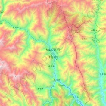
Nome: Mapa topográfico Jiuzhaigou, altitude, relevo.
Altitude média: 2.520 m
Altitude mínima: 1.182 m
Altitude máxima: 4.352 m
Outros mapas topográficos
Clique em um mapa para visualizar sua topografia, sua altitude e seu relevo.
Jiuzhai Valley National Park
China > Sichuan > Jiuzhaigou County
The Jiuzhaigou valley is part of the Min Mountains on the edge of the Tibetan Plateau and stretches over 72,000 hectares (180,000 acres). It is known for its many multi-level waterfalls, colorful lakes, and snow-capped peaks. Its elevation ranges from 2,000 to 4,500 metres (6,600 to 14,800 ft).
Altitude média: 3.424 m