
Mapa topográfico Roxboro
Mapa interativo
Clique no mapa para exibir a altitude.
Roxboro
Roxboro receives an average of 7.2 in (183 mm) of snow per winter. Freezing rain and sleet occur most winters, and occasionally the area experiences a major, damaging ice storm. Roxboro is often dubbed the "Snow Capital of the Triangle" because it often receives the most or close to the most snow during snowstorms in central North Carolina due to its high elevation.
Sobre este mapa
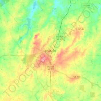
Nome: Mapa topográfico Roxboro, altitude, relevo.
Local: Roxboro, Person County, North Carolina, United States (36.33009 -79.01072 36.45819 -78.94375)
Altitude média: 191 m
Altitude mínima: 134 m
Altitude máxima: 270 m
Outros mapas topográficos
Clique em um mapa para visualizar sua topografia, sua altitude e seu relevo.