
Mapa topográfico Mount Barker
Mapa interativo
Clique no mapa para exibir a altitude.
Sobre este mapa
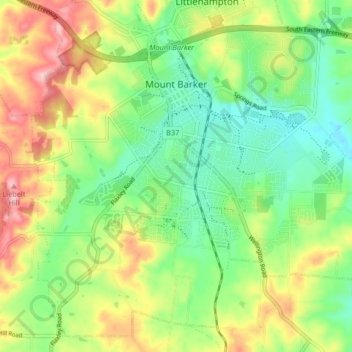
Nome: Mapa topográfico Mount Barker, altitude, relevo.
Altitude média: 368 m
Altitude mínima: 302 m
Altitude máxima: 467 m
Mount Barker is located on the plains surrounding the Mount Barker Summit, about 2 km west of the mountain itself, at 35°04′S 138°51′E / 35.067°S 138.850°E / -35.067; 138.850. Mount Barker is south east of Mount Lofty and Adelaide. It is to the north of The Coorong, and the west of Murray Bridge. Mount Barker is at an elevation of 360 m.