
Faça uma doação
Mapa topográfico San Fernando
Clique no mapa para exibir a altitude.
Faça uma doação
Sobre este mapa
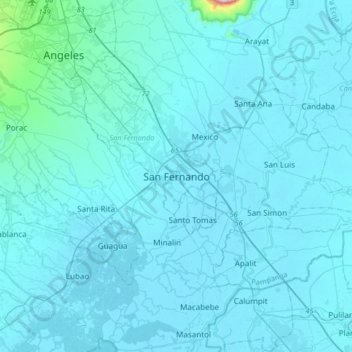
Nome: Mapa topográfico San Fernando, altitude, relevo.
Local: San Fernando, Pampanga, Central Luzon, 2000, Philippines (14.86830 120.53380 15.18830 120.85380)
Altitude média: 24 m
Altitude mínima: -2 m
Altitude máxima: 655 m
Faça uma doação
Outros mapas topográficos
Clique em um mapa para visualizar sua topografia, sua altitude e seu relevo.
Guagua
The climate and topographical features of the vast land of Guagua make it ideal for the growing of fruit trees and vegetables. Among the fruit trees most fitting to be planted are mangoes, guavas, santol, star apples, and bananas. For vegetables, sitao, upo, ampalaya, gabi and cucumber are the most commonly…
Altitude média: 9 m
Faça uma doação
Floridablanca
Floridablanca is located on the western part of Pampanga along the Zambales mountain ranges and is bounded by the municipalities of Porac on the north, Lubao on the south, Guagua on the east, and Dinalupihan, Bataan on the west. It is 40 kilometers (25 mi) from the city of San Fernando and 106 kilometers (66…
Altitude média: 35 m
Faça uma doação
Faça uma doação
Faça uma doação
Faça uma doação
Faça uma doação
Faça uma doação
Faça uma doação
Faça uma doação
Faça uma doação
Faça uma doação
Faça uma doação
Floridablanca
Floridablanca is located on the western part of Pampanga along the Zambales mountain ranges and is bounded by the municipalities of Porac on the north, Lubao on the south, Guagua on the east, and Dinalupihan, Bataan on the west. It is 40 kilometers (25 mi) from the city of San Fernando and 106 kilometers (66…
Altitude média: 35 m
Faça uma doação
Floridablanca
The town is at an elevation of 12 feet (3.7 m) above sea level. Floridablanca is north of Dinalupihan via Dinalupihan-Floridablanca Access Road at the Bataan-Pampanga boundary line.
Altitude média: 35 m
Faça uma doação
Faça uma doação
Floridablanca
The town is at an elevation of 12 feet (3.7 m) above sea level. Floridablanca is north of Dinalupihan via Dinalupihan-Floridablanca Access Road at the Bataan-Pampanga boundary line.
Altitude média: 35 m
Faça uma doação
Floridablanca
The town is at an elevation of 12 feet (3.7 m) above sea level. Floridablanca is north of Dinalupihan via Dinalupihan-Floridablanca Access Road at the Bataan-Pampanga boundary line.
Altitude média: 35 m
Faça uma doação
Floridablanca
The town is at an elevation of 12 feet (3.7 m) above sea level. Floridablanca is north of Dinalupihan via Dinalupihan-Floridablanca Access Road at the Bataan-Pampanga boundary line.
Altitude média: 35 m
Faça uma doação
Faça uma doação
Faça uma doação
Faça uma doação
Faça uma doação
Faça uma doação
Faça uma doação
Guagua
The climate and topographical features of the vast land of Guagua make it ideal for the growing of fruit trees and vegetables. Among the fruit trees most fitting to be planted are mangoes, guavas, santol, star apples, and bananas. For vegetables, sitao, upo, ampalaya, gabi and cucumber are the most commonly…
Altitude média: 9 m