
Obrigado por apoiar este site ❤️
Faça uma doação
Faça uma doação
Mapa topográfico Old Brampton
Clique no mapa para exibir a altitude.
Obrigado por apoiar este site ❤️
Faça uma doação
Faça uma doação
Sobre este mapa
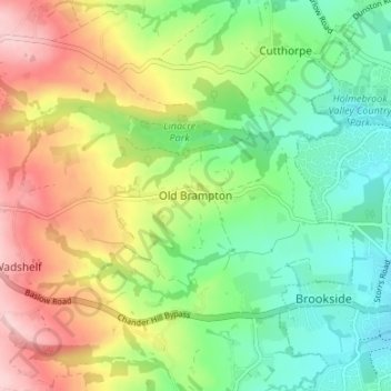
Nome: Mapa topográfico Old Brampton, altitude, relevo.
Altitude média: 181 m
Altitude mínima: 100 m
Altitude máxima: 301 m
Obrigado por apoiar este site ❤️
Faça uma doação
Faça uma doação
Outros mapas topográficos
Clique em um mapa para visualizar sua topografia, sua altitude e seu relevo.
Ashover CP
United Kingdom > England > Derbyshire > North East Derbyshire
By the 18th century, there were several thousand acres of unenclosed moorland in the parish of Ashover, principally covered with heath. The only paths across this wilderness for roads were tracks in the sand or heath with here and there a stone post on the hills or elevations to serve as guides to the…
Altitude média: 210 m
Obrigado por apoiar este site ❤️
Faça uma doação
Faça uma doação