
Mapa topográfico Jüterbog
Mapa interativo
Clique no mapa para exibir a altitude.
Sobre este mapa
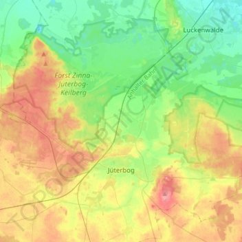
Nome: Mapa topográfico Jüterbog, altitude, relevo.
Local: Jüterbog, Teltow-Fläming, Brandebourg, 14913, Allemagne (51.95493 12.95605 52.09603 13.23333)
Altitude média: 77 m
Altitude mínima: 41 m
Altitude máxima: 133 m
Outros mapas topográficos
Clique em um mapa para visualizar sua topografia, sua altitude e seu relevo.
Neuer Canal vom Schneide Graben zum Notten Fluss
Allemagne > Brandebourg > Teltow-Fläming > Saalow
Neuer Canal vom Schneide Graben zum Notten Fluss, Zossen, Saalow, Am Mellensee, Teltow-Fläming, Brandebourg, 15838, Allemagne
Altitude média: 39 m
Dahme/Mark
Allemagne > Brandebourg > Teltow-Fläming
Dahme/Mark, Teltow-Fläming, Brandebourg, 15936, Allemagne
Altitude média: 105 m