
Mapa topográfico Chammünster
Mapa interativo
Clique no mapa para exibir a altitude.
Sobre este mapa
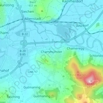
Nome: Mapa topográfico Chammünster, altitude, relevo.
Local: Chammünster, Cham, Landkreis Cham, Bayern, 93413, Deutschland (49.19042 12.67515 49.23042 12.71515)
Altitude média: 399 m
Altitude mínima: 366 m
Altitude máxima: 592 m
Outros mapas topográficos
Clique em um mapa para visualizar sua topografia, sua altitude e seu relevo.
Selling
Deutschland > Bayern > Landkreis Cham > Cham > Kothmaißling
Selling, Kothmaißling, Cham, Landkreis Cham, Bayern, 93486, Deutschland
Altitude média: 399 m
Haidhäuser
Deutschland > Bayern > Landkreis Cham > Cham
Haidhäuser, Cham, Landkreis Cham, Bayern, Deutschland
Altitude média: 381 m
Gutmaning
Deutschland > Bayern > Landkreis Cham > Cham
Gutmaning, Cham, Landkreis Cham, Bayern, 93413, Deutschland
Altitude média: 412 m
Laichstätt
Deutschland > Bayern > Landkreis Cham > Cham
Laichstätt, Cham, Landkreis Cham, Bayern, 93482, Deutschland
Altitude média: 374 m