
Mapa topográfico Basehor
Mapa interativo
Clique no mapa para exibir a altitude.
Sobre este mapa
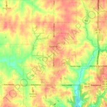
Nome: Mapa topográfico Basehor, altitude, relevo.
Local: Basehor, Leavenworth County, Kansas, 66007, United States (39.10171 -94.97354 39.17237 -94.90056)
Altitude média: 286 m
Altitude mínima: 250 m
Altitude máxima: 308 m
Outros mapas topográficos
Clique em um mapa para visualizar sua topografia, sua altitude e seu relevo.
Maywood
United States > Kansas > Leavenworth County > Leavenworth
Maywood, Leavenworth, Leavenworth County, Kansas, 64092, United States
Altitude média: 246 m
Fairmount
United States > Kansas > Leavenworth County
Fairmount, Leavenworth County, Kansas, United States
Altitude média: 290 m
Leavenworth
United States > Kansas > Leavenworth County
Leavenworth, Leavenworth County, Kansas, United States
Altitude média: 268 m
Linwood
United States > Kansas > Leavenworth County
Linwood, Leavenworth County, Kansas, United States
Altitude média: 248 m
Hoge
United States > Kansas > Leavenworth County
Hoge, Leavenworth County, Kansas, United States
Altitude média: 276 m
Fort Leavenworth
United States > Kansas > Leavenworth County > Leavenworth > Leavenworth
Fort Leavenworth, Leavenworth, Leavenworth County, Kansas, 66027, United States
Altitude média: 252 m
Lansing
United States > Kansas > Leavenworth County
Lansing, Leavenworth County, Kansas, 66043, United States
Altitude média: 266 m
Leavenworth
United States > Kansas > Leavenworth County > Leavenworth
Leavenworth, Leavenworth County, Kansas, 66048, United States
Altitude média: 277 m