
Faça uma doação
Mapa topográfico Baybay
Clique no mapa para exibir a altitude.
Faça uma doação
Baybay
The climate is of Coronas Climate type IV, which is generally wet with no particularly discernible seasons. Its topography is generally mountainous in the eastern portion as it slopes down west towards the shore line. Generally an agricultural city, the common means of livelihood are farming and fishing. Some are engaged in hunting and in forestal activities. The most common crops grown are rice, corn, abaca, root crops, fruits, and vegetables. Various cottage industries can also be found in Baybay such as bamboo and rattan craft, ceramics, dress-making, fiber craft, food preservation, mat weaving, metal craft, furniture manufacture and other related activities.
Faça uma doação
Sobre este mapa
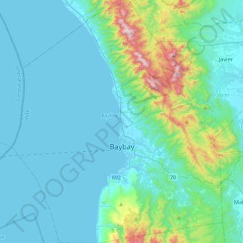
Nome: Mapa topográfico Baybay, altitude, relevo.
Altitude média: 157 m
Altitude mínima: 0 m
Altitude máxima: 1.137 m
Faça uma doação
Outros mapas topográficos
Clique em um mapa para visualizar sua topografia, sua altitude e seu relevo.
Faça uma doação
Faça uma doação
Faça uma doação
Faça uma doação
Faça uma doação