
Obrigado por apoiar este site ❤️
Faça uma doação
Faça uma doação
Mapa topográfico Camp Mercier
Clique no mapa para exibir a altitude.
Obrigado por apoiar este site ❤️
Faça uma doação
Faça uma doação
Sobre este mapa
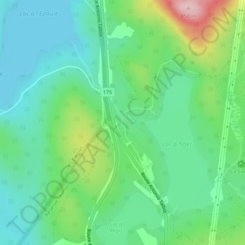
Nome: Mapa topográfico Camp Mercier, altitude, relevo.
Altitude média: 706 m
Altitude mínima: 642 m
Altitude máxima: 866 m
Obrigado por apoiar este site ❤️
Faça uma doação
Faça uma doação
Outros mapas topográficos
Clique em um mapa para visualizar sua topografia, sua altitude e seu relevo.
Forêt Montmorency
Canada > Quebec > La Côte-de-Beaupré > Lac-Jacques-Cartier
Located in the Laurentian Mountains, the Montmorency forest is drained by the Montmorency River and by one of its tributaries, the Black river. There are four lakes: Lac Piché, Bédard, Laflamme and Joncas. The altitude varies between 600 and 1,000 meters (3,300 ft) with an average of 750 meters. The…
Altitude média: 794 m
Obrigado por apoiar este site ❤️
Faça uma doação
Faça uma doação