
Faça uma doação
Mapa topográfico East Point
Clique no mapa para exibir a altitude.
Faça uma doação
Sobre este mapa
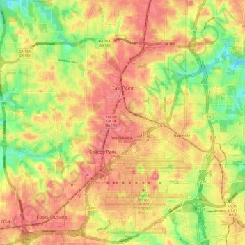
Nome: Mapa topográfico East Point, altitude, relevo.
Local: East Point, Fulton County, Georgia, 30344, United States (33.62514 -84.53559 33.70571 -84.41505)
Altitude média: 295 m
Altitude mínima: 247 m
Altitude máxima: 328 m
Faça uma doação
Outros mapas topográficos
Clique em um mapa para visualizar sua topografia, sua altitude e seu relevo.
Atlanta
United States > Georgia > Fulton County
Atlanta (/ætˈlæntə/ at-LAN-tə) is the capital and most populous city of the U.S. state of Georgia. It is the seat of Fulton County, the most populous county in Georgia. With a population of 498,715 living within the city limits, it is the eighth most populous city in the Southeast and 38th most populous…
Altitude média: 285 m
Faça uma doação
Capital City Country Club Lake Dam
United States > Georgia > Fulton County > Atlanta
Altitude média: 294 m
Faça uma doação
Faça uma doação
Johns Creek
United States > Georgia > Fulton County > Johns Creek
Johns Creek is located in northeastern Fulton County and is centered at 34°1′44″N 84°11′55″W / 34.02889°N 84.19861°W / 34.02889; -84.19861 (34.0289259, -84.1985790). The elevation ranges from 880 feet (270 m) above sea level along the Chattahoochee River to 1,180 feet (360 m) in the Ocee…
Altitude média: 314 m
Faça uma doação