
Obrigado por apoiar este site ❤️
Faça uma doação
Faça uma doação
Mapa topográfico Greenvale
Clique no mapa para exibir a altitude.
Obrigado por apoiar este site ❤️
Faça uma doação
Faça uma doação
Sobre este mapa
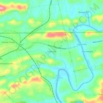
Nome: Mapa topográfico Greenvale, altitude, relevo.
Local: Greenvale, Hawkins County, Tennessee, 37665, United States (36.56677 -82.64016 36.60677 -82.60016)
Altitude média: 404 m
Altitude mínima: 357 m
Altitude máxima: 509 m
Obrigado por apoiar este site ❤️
Faça uma doação
Faça uma doação
Outros mapas topográficos
Clique em um mapa para visualizar sua topografia, sua altitude e seu relevo.
Bays Mountain
United States > Tennessee > Hawkins County
The southern segment of Bays Mountain is relatively low in elevation (up to about 1,300 feet (396.2 m)). In some places it essentially merges with the surrounding plains, especially where it is bisected by the French Broad River and the Nolichucky River. The northern segment of Bays Mountain reaches higher…
Altitude média: 419 m