
Mapa topográfico McKenzie River
Mapa interativo
Clique no mapa para exibir a altitude.
Sobre este mapa
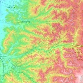
Nome: Mapa topográfico McKenzie River, altitude, relevo.
Local: McKenzie River, Lane County, Oregon, United States (44.05292 -123.10739 44.36102 -121.99422)
Altitude média: 698 m
Altitude mínima: 76 m
Altitude máxima: 2.025 m
The McKenzie River drains a region of about 1,300 square miles (3,400 km2) and is one of the primary tributaries of the Willamette River. Elevations in the watershed range from 10,358 feet (3,157 m) at the summit of the South Sister to 375 feet (114 m) at the McKenzie's mouth on the Willamette River north of Eugene. The upper basin, in the high Cascades, consists of granular, permeable igneous rocks that are geologically young, while most of the middle and lower McKenzie valley in the Western Cascades is made of the remnants of older, more weathered volcanic rocks. Major watersheds bordering the McKenzie basin include the Calapooia; the South, Middle and North Santiam rivers to the north; the Middle Fork Willamette River to the south; and the Deschutes River to the east.
Outros mapas topográficos
Clique em um mapa para visualizar sua topografia, sua altitude e seu relevo.
Eugene
United States > Oregon > Lane County
Eugene, Lane County, Oregon, United States
Altitude média: 163 m
Florence
United States > Oregon > Lane County
Florence, Lane County, Oregon, United States
Altitude média: 22 m
Cheshire
United States > Oregon > Lane County > Cheshire
Cheshire, Lane County, Oregon, 97419, United States
Altitude média: 109 m
Pleasant Hill
United States > Oregon > Lane County
Pleasant Hill, Lane County, Oregon, 97455, United States
Altitude média: 183 m
Mapleton
United States > Oregon > Lane County
Mapleton, Lane County, Oregon, 97453, United States
Altitude média: 131 m
Leaburg
United States > Oregon > Lane County
Leaburg, Lane County, Oregon, United States
Altitude média: 355 m
McKenzie River
United States > Oregon > Lane County > Rainbow
McKenzie River, Rainbow, Lane County, Oregon, 97413, United States
Altitude média: 431 m
Dorena Lake
United States > Oregon > Lane County
Dorena Lake, Lane County, Oregon, United States
Altitude média: 331 m
Cheshire
United States > Oregon > Lane County
Cheshire, Lane County, Oregon, United States
Altitude média: 109 m
Oakridge
United States > Oregon > Lane County
Oakridge, Lane County, Oregon, United States
Altitude média: 465 m
Waldo Lake Wilderness
United States > Oregon > Lane County
Waldo Lake Wilderness, Lane County, Oregon, United States
Altitude média: 1.528 m
Coburg
United States > Oregon > Lane County
Coburg, Lane County, Oregon, 97408, United States
Altitude média: 120 m
Cottage Grove
United States > Oregon > Lane County
Cottage Grove, Lane County, Oregon, 97424, United States
Altitude média: 230 m
Swisshome
United States > Oregon > Lane County
Swisshome, Lane County, Oregon, 97480, United States
Altitude média: 222 m
Veneta
United States > Oregon > Lane County
Veneta, Lane County, Oregon, 97487, United States
Altitude média: 133 m
Westfir
United States > Oregon > Lane County
Westfir, Lane County, Oregon, 47492, United States
Altitude média: 442 m
Disston
United States > Oregon > Lane County
Disston, Lane County, Oregon, United States
Altitude média: 512 m
Lowell
United States > Oregon > Lane County
Lowell, Lane County, Oregon, 97452, United States
Altitude média: 261 m
Marcola
United States > Oregon > Lane County
Marcola, Lane County, Oregon, United States
Altitude média: 223 m
Elmira
United States > Oregon > Lane County > Elmira
Elmira, Lane County, Oregon, United States
Altitude média: 120 m
Washington/Jefferson City Park
United States > Oregon > Lane County > Eugene
Washington/Jefferson City Park, Eugene, Lane County, Oregon, United States
Altitude média: 130 m
Rainbow
United States > Oregon > Lane County
Rainbow, Lane County, Oregon, 97413, United States
Altitude média: 486 m
Noti
United States > Oregon > Lane County > Noti
Noti, Lane County, Oregon, 97461, United States
Altitude média: 201 m
West Bank City Park
United States > Oregon > Lane County > Eugene
West Bank City Park, Bethel, Eugene, Lane County, Oregon, United States
Altitude média: 125 m
Springfield
United States > Oregon > Lane County
Springfield, Lane County, Oregon, United States
Altitude média: 177 m
Walton
United States > Oregon > Lane County
Walton, Lane County, Oregon, United States
Altitude média: 231 m
Cupit Mary Mountain
United States > Oregon > Lane County
Cupit Mary Mountain, Lane County, Oregon, United States
Altitude média: 1.702 m
Dorena
United States > Oregon > Lane County > Dorena
Dorena, Lane County, Oregon, 97434, United States
Altitude média: 434 m
Culp Creek
United States > Oregon > Lane County > Culp Creek
Culp Creek, Lane County, Oregon, 97434, United States
Altitude média: 474 m
Saddle Camp Butte
United States > Oregon > Lane County
Saddle Camp Butte, Lane County, Oregon, United States
Altitude média: 973 m
Junction City
United States > Oregon > Lane County
Junction City, Lane County, Oregon, United States
Altitude média: 102 m
McKenzie Bridge
United States > Oregon > Lane County
McKenzie Bridge, Lane County, Oregon, 97413, United States
Altitude média: 521 m
Waldo Lake
United States > Oregon > Lane County
Waldo Lake, Lane County, Oregon, United States
Altitude média: 1.687 m
Creswell
United States > Oregon > Lane County
Creswell, Lane County, Oregon, 97426, United States
Altitude média: 165 m
Mount Popocatepetl
United States > Oregon > Lane County
Mount Popocatepetl, Lane County, Oregon, United States
Altitude média: 163 m
Fuji Mountain
United States > Oregon > Lane County
Fuji Mountain, Lane County, Oregon, United States
Altitude média: 1.885 m