
Obrigado por apoiar este site ❤️
Faça uma doação
Faça uma doação
Mapa topográfico Sumucab
Clique no mapa para exibir a altitude.
Obrigado por apoiar este site ❤️
Faça uma doação
Faça uma doação
Sobre este mapa
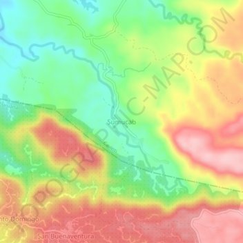
Nome: Mapa topográfico Sumucab, altitude, relevo.
Local: Sumucab, Cavinti, Laguna, Calabarzon, Philippines (14.19398 121.54428 14.23398 121.58428)
Altitude média: 370 m
Altitude mínima: 281 m
Altitude máxima: 459 m
Obrigado por apoiar este site ❤️
Faça uma doação
Faça uma doação
Outros mapas topográficos
Clique em um mapa para visualizar sua topografia, sua altitude e seu relevo.
Bumbungan River
Philippines > Laguna > Cavinti
The waterfalls for which the Bumbungan river is famous is the Magdapio Falls, a section of the river in the town of Cavinti where the river drops about 300 feet (91 m). Because the original boat ride to reach the falls starts in Pagsanjan, it became known as the Pagsanjan Falls. This round trip boat ride…
Altitude média: 260 m
Obrigado por apoiar este site ❤️
Faça uma doação
Faça uma doação