
Mapa topográfico Tipner
Mapa interativo
Clique no mapa para exibir a altitude.
Sobre este mapa
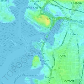
Nome: Mapa topográfico Tipner, altitude, relevo.
Local: Tipner, Portsmouth, England, PO2 8RD, United Kingdom (50.80673 -1.11263 50.84673 -1.07263)
Altitude média: 3 m
Altitude mínima: -4 m
Altitude máxima: 18 m
Outros mapas topográficos
Clique em um mapa para visualizar sua topografia, sua altitude e seu relevo.
Portsea Island
United Kingdom > England > Portsmouth
Portsea Island, Portsmouth, England, United Kingdom
Altitude média: 3 m
Portsdown Hill
United Kingdom > England > Portsmouth
Portsdown Hill, Portsdown Hill Road, Wymering, Cosham, Portsmouth, South East, England, PO6 3LS, United Kingdom
Altitude média: 39 m
Bastion 3, Hilsea Lines
United Kingdom > England > Portsmouth
Bastion 3, Hilsea Lines, Scott Road, Hilsea, Portsmouth, England, PO3 5LX, United Kingdom
Altitude média: 4 m
Gobs Barrow
United Kingdom > England > Portsmouth
Gobs Barrow, Portsdown Hill Road, Drayton, Portsmouth, South East England, England, PO6 1BG, United Kingdom
Altitude média: 40 m
Hilsea Lines
United Kingdom > England > Portsmouth > Tipner
Hilsea Lines, Hilsea Crescent, Hilsea, Tipner, Portsmouth, South East, England, PO2 9SN, United Kingdom
Altitude média: 5 m
Victoria Park
United Kingdom > England > Portsmouth
Victoria Park, Stamshaw, Portsea, Portsmouth, South East, England, PO1 3HJ, United Kingdom
Altitude média: 4 m
Fort Cumberland
United Kingdom > England > Portsmouth
Fort Cumberland, Portsmouth, South East, England, PO4 9LD, United Kingdom
Altitude média: 1 m