
Faça uma doação
Mapa topográfico Lake Tahoe Basin Management Unit
Clique no mapa para exibir a altitude.
Faça uma doação
Lake Tahoe Basin Management Unit
The Lake Tahoe Basin Management Unit is a United States National Forest that manages and protects public land surrounding Lake Tahoe and the Lake Tahoe Basin. Straddling the state borders of California and Nevada in the Sierra Nevada, the LTBMU encompasses 154,851 acres (626 km²) of National Forest system lands, ranging in altitude above sea level from 6,225 feet (1,897 m) at lake level to 10,881 feet (3,317 m) at Freel Peak. The U.S. Forest Service established the LTBMU in 1973. The name of the Lake Tahoe Basin Management Unit reflects a unique sort of National Forest.
Faça uma doação
Sobre este mapa
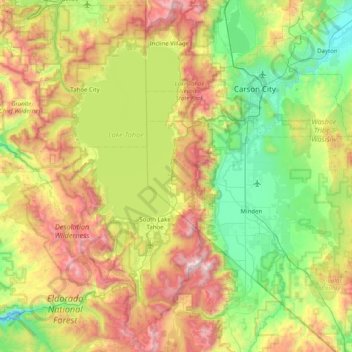
Nome: Mapa topográfico Lake Tahoe Basin Management Unit, altitude, relevo.
Altitude média: 1.981 m
Altitude mínima: 1.296 m
Altitude máxima: 3.294 m
Faça uma doação
Outros mapas topográficos
Clique em um mapa para visualizar sua topografia, sua altitude e seu relevo.
Fallen Leaf Lake
United States > California > El Dorado County
The surface elevation of the lake is 152 feet (46 m) above Lake Tahoe.
Altitude média: 2.068 m
Pollock Pines
United States > California > El Dorado County
Pollock Pines is a census-designated place (CDP) in El Dorado County, California, United States. It is part of the Sacramento–Arden-Arcade–Roseville Metropolitan Statistical Area. Pollock Pines lies at an elevation of 3,980 feet (1,210 m) in the Sierra Nevada. The population was 6,871 at the 2010 census,…
Altitude média: 1.122 m
Rescue
United States > California > El Dorado County
Rescue, formerly Green Valley, El Dorado County, California, is an unincorporated community in El Dorado County, California. It is located north-northwest of Shingle Springs and north-northeast of Cameron Park. The zip code is 95672, and Rescue is located in area code 530. The town lies at an elevation of 1214…
Altitude média: 393 m
Faça uma doação
Faça uma doação
El Dorado
United States > California > El Dorado County
El Dorado (Spanish for "The Golden") is an unincorporated community in El Dorado County, California. It is located 4 miles (6.4 km) southwest of Placerville, at an elevation of 1608 feet (490 m). The population was 4,096 at the 2000 census. The town is registered as California Historical Landmark #486. The ZIP…
Altitude média: 511 m
Cameron Park
United States > California > El Dorado County
Cameron Park is situated in an interior chaparral zone or brush zone just east of the Central Valley. It is the closest population center to the Pine Hill Ecological Reserve. Native vegetation includes an abundance of redbud and manzanita bushes, and brush in general. Where treed the native trees are primarily…
Altitude média: 390 m
Faça uma doação
South Lake Tahoe
United States > California > El Dorado County > South Lake Tahoe > South Lake Tahoe
Altitude média: 1.944 m
Diamond Springs
United States > California > El Dorado County
Diamond Springs (formerly, Diamond Spring and Diamond) is a census-designated place (CDP) in El Dorado County, California, United States. It is part of the Sacramento–Arden-Arcade–Roseville Metropolitan Statistical Area. The population was 11,037 at the 2010 census, up from 4,888 at the 2000 census. The…
Altitude média: 531 m
Faça uma doação
Laurel Oaks Park
United States > California > El Dorado County > Cameron Park > Bar J Ranch
Altitude média: 380 m
Kingsville
United States > California > El Dorado County
Kingsville (formerly, Kingville) is an unincorporated community in El Dorado County, California. It is located 5 miles (8 km) southwest of Placerville, at an elevation of 1532 feet (467 m).
Altitude média: 473 m
Faça uma doação
Cameron Airpark Estates
United States > California > El Dorado County > Cameron Park
Altitude média: 411 m
Faça uma doação
Tallac Village
United States > California > El Dorado County > South Lake Tahoe
Altitude média: 1.945 m
Faça uma doação
Faça uma doação
Echo Summit
United States > California > El Dorado County
Echo Summit is notable for being the location (sometimes listed as "South Lake Tahoe") of the 1968 U.S. Olympic track and field trials for men, held September 6–16, a month before the 1968 Olympics in Mexico City. (The women's trials were at low altitude in Los Angeles County, at Walnut.) The Echo Summit…
Altitude média: 2.200 m
Faça uma doação
South Lake Tahoe-El Dorado Recreation Area
United States > California > El Dorado County > South Lake Tahoe > Bijou
Altitude média: 1.905 m
Faça uma doação
El Dorado Hills
United States > California > El Dorado County > Folsom
El Dorado Hills (EDH), as defined by the 2010 census-designated place (CDP), is at the western border of El Dorado County, between the City of Folsom and the unincorporated community of Cameron Park. The northern limits of the CDP are Folsom Lake and the South Fork of the American River, where river rafters…
Altitude média: 243 m
Faça uma doação