
Faça uma doação
Mapa topográfico Dinara
Clique no mapa para exibir a altitude.
Faça uma doação
Sobre este mapa
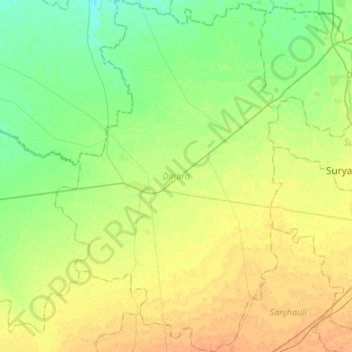
Nome: Mapa topográfico Dinara, altitude, relevo.
Local: Dinara, Rohtas District, Bihar, India (25.13239 83.99958 25.37524 84.17330)
Altitude média: 82 m
Altitude mínima: 70 m
Altitude máxima: 94 m
Faça uma doação
Outros mapas topográficos
Clique em um mapa para visualizar sua topografia, sua altitude e seu relevo.
Gaya
India > Bihar > Gaya Town C.D.Block
Gaya is connected to the rest of India by roads, rail and airways. The Grand Chord section of the Indian Railways passes through Gaya. Gaya Junction railway station railway station is a major junction station serving the city. Gaya Junction has been redeveloped as Model railway station recently and houses all…
Altitude média: 111 m
Faça uma doação
Faça uma doação
Wazirganj
Wazirganj is a historical place from time of *Alha, Udal* This is the oldest temple of Khere Wali Maiya, where Alha and Udal had arrived. Wazirganj is located at 28°13′N 79°03′E / 28.22°N 79.05°E / 28.22; 79.05. It has an average elevation of 174 metres (570 feet).
Altitude média: 111 m
Faça uma doação
Faça uma doação
Faça uma doação
Faça uma doação
Faça uma doação
Jajuara
The climate is mainly dry and cool. In summer the temperature varies from 35 °C (95 °F) to 45 °C (113 °F). In winter it is typically 5 °C (41 °F) to 15 °C (59 °F). The elevation is 51m close to sea level. The soil is suited for agriculture, which is the main economic activity of the region.
Altitude média: 53 m
Faça uma doação
Siwan
Siwan city is located at coordinates 26°13′N 84°22′E / 26.22°N 84.36°E / 26.22; 84.36 Latitude and longitude. It is counted in one of the tarai region of Himalaya Mountain range. It has an average elevation of 72 metres (236 ft). Daha River, which is a small river, which floods in rainy season…
Altitude média: 64 m
Arrah
Arrah is located at the elevation of 192 m from the sea level at the bank of Son river, Ganga River and Gangi River. Arrah lies at the confluence of the Ganga and the Son River, other small rivers that flow in the town are Gangi River, Badki Nadi and Chhotki Nadi.
Altitude média: 59 m
Faça uma doação
Faça uma doação
Faça uma doação
Faça uma doação
Faça uma doação
Faça uma doação
Faça uma doação
Faça uma doação