
Mapa topográfico Wallstreet
Clique no mapa para exibir a altitude.
Sobre este mapa
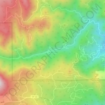
Nome: Mapa topográfico Wallstreet, altitude, relevo.
Local: Wallstreet, Boulder County, Colorado, United States (40.01887 -105.41083 40.05887 -105.37083)
Altitude média: 2.266 m
Altitude mínima: 1.940 m
Altitude máxima: 2.658 m
Outros mapas topográficos
Clique em um mapa para visualizar sua topografia, sua altitude e seu relevo.
Nederland
United States > Colorado > Boulder County
In 1873 the Caribou Mine, at an elevation of roughly 10,000 feet (3,000 m) and 6 miles (10 km) northwest of the town, was sold to the Mining Company Nederland from the Netherlands. The high elevation meant fierce winds and deep winter snow, so the new owners of the mine decided that it was beneficial to bring…
Altitude média: 2.578 m
Jamestown
United States > Colorado > Boulder County
Jamestown is in central Boulder County at 40°6′56″N 105°23′15″W / 40.11556°N 105.38750°W / 40.11556; -105.38750 (40.115485, −105.387531). It lies along James Creek within the Front Range of the Colorado Rockies, with access via James Canyon Drive, which leads east 8 miles (13 km) to U.S.…
Altitude média: 2.271 m
University of Colorado Boulder (Williams Village)
United States > Colorado > Boulder County > Boulder
Altitude média: 1.634 m
Fredrick Law Olmsted, Jr. Park
United States > Colorado > Boulder County > Boulder
Altitude média: 1.664 m
National Center for Atmospheric Research
United States > Colorado > Boulder County > Boulder
Altitude média: 1.816 m