
Mapa topográfico Grey Green
Clique no mapa para exibir a altitude.
Sobre este mapa
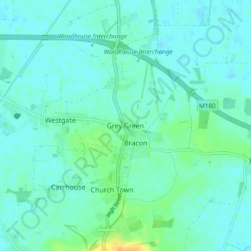
Nome: Mapa topográfico Grey Green, altitude, relevo.
Altitude média: 6 m
Altitude mínima: 0 m
Altitude máxima: 29 m
Outros mapas topográficos
Clique em um mapa para visualizar sua topografia, sua altitude e seu relevo.
Barrow-upon-Humber
United Kingdom > England > North Lincolnshire > Barrow-upon-Humber
Altitude média: 18 m
Haxey
United Kingdom > England > North Lincolnshire
The civil parish includes the town of Haxey and the village of Westwoodside, and the hamlets of Haxey Carr, High Burnham (the highest elevation of the Isle of Axholme), Low Burnham, East Lound, Graizelound and Upperthorpe which is conjoined to Westwoodside.
Altitude média: 7 m