
Mapa topográfico Warren
Mapa interativo
Clique no mapa para exibir a altitude.
Sobre este mapa
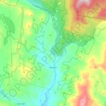
Nome: Mapa topográfico Warren, altitude, relevo.
Local: Warren, Grafton County, New Hampshire, United States (43.88589 -71.96324 43.99825 -71.78977)
Altitude média: 475 m
Altitude mínima: 184 m
Altitude máxima: 1.166 m
From 1909 until 1970, Glencliff, located in the northern part of Warren, was the mailing address for the New Hampshire State Sanatorium, located just over the town line in Benton, at an elevation of 1,650 feet (500 m) on the slopes of Mount Moosilauke. Before the discovery of antibiotics, pure mountain air was thought to be curative for patients with tuberculosis. With its own farm on 500 acres (200 ha), the facility treated more than 4,000 individuals over its first half century, admitting between 50 and 100 per year. Many came from the industrial cities of southern New Hampshire such as Concord, Manchester and Nashua. It is now the Glencliff Home for the Elderly.
Outros mapas topográficos
Clique em um mapa para visualizar sua topografia, sua altitude e seu relevo.
Lyman
United States > New Hampshire > Grafton County
Lyman, Grafton County, New Hampshire, United States
Altitude média: 347 m
Bonsai
United States > New Hampshire > Grafton County > Rumney
Bonsai, Rumney, Grafton County, New Hampshire, 03266, United States
Altitude média: 246 m
Franconia
United States > New Hampshire > Grafton County
Franconia, Grafton County, New Hampshire, 03580, United States
Altitude média: 558 m
Waterville Valley
United States > New Hampshire > Grafton County
Waterville Valley, Grafton County, New Hampshire, 03215, United States
Altitude média: 649 m
Groton
United States > New Hampshire > Grafton County
Groton, Grafton County, New Hampshire, United States
Altitude média: 366 m
Plymouth
United States > New Hampshire > Grafton County
Plymouth, Grafton County, New Hampshire, 03264, United States
Altitude média: 264 m
Wentworth
United States > New Hampshire > Grafton County
Wentworth, Grafton County, New Hampshire, 03282, United States
Altitude média: 422 m
Bath
United States > New Hampshire > Grafton County
Bath, Grafton County, New Hampshire, 03740, United States
Altitude média: 289 m
Stinson Lake
United States > New Hampshire > Grafton County > Rumney > Stinson Lake
Stinson Lake, Rumney, Grafton County, New Hampshire, United States
Altitude média: 460 m
North Haverhill
United States > New Hampshire > Grafton County > Haverhill
North Haverhill, Haverhill, Grafton County, New Hampshire, 03774, United States
Altitude média: 149 m
Echo Lake
United States > New Hampshire > Grafton County > Franconia
Echo Lake, Franconia, Grafton County, New Hampshire, United States
Altitude média: 693 m
Lebanon
United States > New Hampshire > Grafton County
Lebanon, Grafton County, New Hampshire, United States
Altitude média: 274 m
Mount Kineo, East Peak
United States > New Hampshire > Grafton County > Ellsworth
Mount Kineo, East Peak, Ellsworth, Grafton County, New Hampshire, United States
Altitude média: 710 m
Etna
United States > New Hampshire > Grafton County > Hanover
Etna, Hanover, Grafton County, New Hampshire, 03750, United States
Altitude média: 296 m
Holderness
United States > New Hampshire > Grafton County
Holderness, Grafton County, New Hampshire, 03245, United States
Altitude média: 252 m
Bristol
United States > New Hampshire > Grafton County
Bristol, Grafton County, New Hampshire, 03222, United States
Altitude média: 254 m
Enfield
United States > New Hampshire > Grafton County
Enfield, Grafton County, New Hampshire, United States
Altitude média: 366 m
Sugar Hill
United States > New Hampshire > Grafton County > Sugar Hill
Sugar Hill, Grafton County, New Hampshire, 03586, United States
Altitude média: 372 m
Mount Agassiz
United States > New Hampshire > Grafton County > Bethlehem
Mount Agassiz, Bethlehem, Grafton County, New Hampshire, 03574, United States
Altitude média: 558 m
Littleton
United States > New Hampshire > Grafton County > Littleton
Littleton, Grafton County, New Hampshire, United States
Altitude média: 360 m
North Littleton
United States > New Hampshire > Grafton County > Littleton > North Littleton
North Littleton, Littleton, Grafton County, New Hampshire, United States
Altitude média: 333 m
West Lebanon
United States > New Hampshire > Grafton County > Lebanon > West Lebanon
West Lebanon, Lebanon, Grafton County, New Hampshire, 03784, United States
Altitude média: 165 m
Lebanon
United States > New Hampshire > Grafton County > Lebanon
Lebanon, Grafton County, New Hampshire, 03766-1355, United States
Altitude média: 315 m
LeBruns Mobile Home Park
United States > New Hampshire > Grafton County > Lebanon > LeBruns Mobile Home Park
LeBruns Mobile Home Park, Lebanon, Grafton County, New Hampshire, United States
Altitude média: 326 m
Thornton
United States > New Hampshire > Grafton County
Thornton, Grafton County, New Hampshire, United States
Altitude média: 474 m
Bethlehem
United States > New Hampshire > Grafton County > Bethlehem
Bethlehem, Grafton County, New Hampshire, 03574, United States
Altitude média: 528 m
Easton
United States > New Hampshire > Grafton County
Easton, Grafton County, New Hampshire, United States
Altitude média: 586 m
Lincoln
United States > New Hampshire > Grafton County
Lincoln, Grafton County, New Hampshire, 03251, United States
Altitude média: 677 m
Lyme
United States > New Hampshire > Grafton County
Lyme, Grafton County, New Hampshire, United States
Altitude média: 297 m
Orford
United States > New Hampshire > Grafton County
Orford, Grafton County, New Hampshire, United States
Altitude média: 300 m