
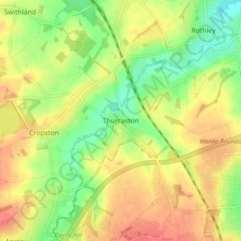
Mapa topográfico Thurcaston
Mapa interativo
Clique no mapa para exibir a altitude.
Sobre este mapa
Nome: Mapa topográfico Thurcaston, altitude, relevo.
Altitude média: 73 m
Altitude mínima: 45 m
Altitude máxima: 97 m
Outros mapas topográficos
Clique em um mapa para visualizar sua topografia, sua altitude e seu relevo.
Mammoth Lake
United Kingdom > England > Leicestershire > Borough of Charnwood > Thurmaston
Mammoth Lake, Thurmaston, Borough of Charnwood, Leicestershire, England, United Kingdom
Altitude média: 58 m
Barkby Thorpe
United Kingdom > England > Leicestershire > Borough of Charnwood
Barkby Thorpe, Borough of Charnwood, Leicestershire, England, United Kingdom
Altitude média: 89 m
Charnwood Forest Canal (Disused)
United Kingdom > England > Leicestershire > Borough of Charnwood > Nanpantan
Charnwood Forest Canal (Disused), Nanpantan, Borough of Charnwood, Leicestershire, England, LE11 3YA, United Kingdom
Altitude média: 98 m
Anstey
United Kingdom > England > Leicestershire > Borough of Charnwood
Anstey, Borough of Charnwood, Leicestershire, England, United Kingdom
Altitude média: 84 m
Wanlip
United Kingdom > England > Leicestershire > Borough of Charnwood
Wanlip, Borough of Charnwood, Leicestershire, England, LE7 4PH, United Kingdom
Altitude média: 61 m
Ratcliffe on the Wreake
United Kingdom > England > Leicestershire > Borough of Charnwood
Ratcliffe on the Wreake, Borough of Charnwood, Leicestershire, England, LE7 4SN, United Kingdom
Altitude média: 68 m
Seagrave
United Kingdom > England > Leicestershire > Borough of Charnwood
Seagrave, Borough of Charnwood, Leicestershire, England, LE12 7NL, United Kingdom
Altitude média: 92 m