
Mapa topográfico Hoeksche Waard
Mapa interativo
Clique no mapa para exibir a altitude.
Sobre este mapa
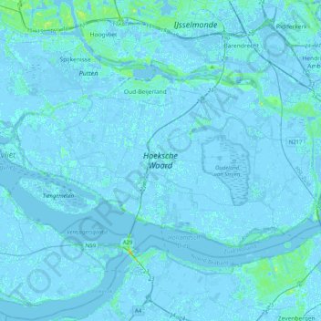
Nome: Mapa topográfico Hoeksche Waard, altitude, relevo.
Local: Hoeksche Waard, Südholland, Niederlande (51.70053 4.22756 51.83444 4.62959)
Altitude média: 0 m
Altitude mínima: -5 m
Altitude máxima: 19 m
Outros mapas topográficos
Clique em um mapa para visualizar sua topografia, sua altitude e seu relevo.
Hoeksche Waard
Niederlande > Südholland > Hoeksche Waard
Hoeksche Waard, Südholland, Niederlande
Altitude média: 0 m
's-Gravendeel
Niederlande > Südholland > Hoeksche Waard
's-Gravendeel, Hoeksche Waard, Südholland, Niederlande
Altitude média: 0 m
Strijensas
Niederlande > Südholland > Hoeksche Waard
Strijensas, Hoeksche Waard, Südholland, Niederlande
Altitude média: 0 m
Klaaswaal
Niederlande > Südholland > Hoeksche Waard
Klaaswaal, Hoeksche Waard, Südholland, Niederlande
Altitude média: 0 m
Mijnsheerenland
Niederlande > Südholland > Hoeksche Waard
Mijnsheerenland, Hoeksche Waard, Südholland, Niederlande
Altitude média: 0 m
Strijen
Niederlande > Südholland > Hoeksche Waard
Strijen, Hoeksche Waard, Südholland, Niederlande
Altitude média: -1 m
Goudswaard
Niederlande > Südholland > Hoeksche Waard
Goudswaard, Hoeksche Waard, Südholland, Niederlande
Altitude média: 0 m
Numansdorp
Niederlande > Südholland > Hoeksche Waard
Numansdorp, Hoeksche Waard, Südholland, Niederlande
Altitude média: 0 m