
Mapa topográfico Chilliwack
Clique no mapa para exibir a altitude.
Sobre este mapa
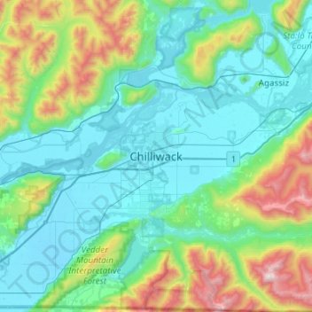
Nome: Mapa topográfico Chilliwack, altitude, relevo.
Altitude média: 381 m
Altitude mínima: -1 m
Altitude máxima: 1.986 m
Outros mapas topográficos
Clique em um mapa para visualizar sua topografia, sua altitude e seu relevo.
Mission
Canada > British Columbia > Fraser Valley Regional District
The western part of the district, the Stave Valley, is largely rural and forested but its watercourse is home to what was the largest hydroelectric project in British Columbia until the Bridge River Power Project opened in 1961. It was built by the British Columbia Electric Railway (BCER) to provide power to…
Altitude média: 345 m
Jones Lake
Canada > British Columbia > Fraser Valley Regional District > Area D (Popkum/Bridal Falls/Wahleach)
Altitude média: 956 m
Area A (Boston Bar/North Bend/Canyon Alpine)
Canada > British Columbia > Fraser Valley Regional District
Altitude média: 1.260 m
Area E (Chilliwack River Valley)
Canada > British Columbia > Fraser Valley Regional District
Altitude média: 1.032 m
Harrison River
Canada > British Columbia > Fraser Valley Regional District > Kent > Harrison Mills
Altitude média: 45 m
Sumas River
Canada > British Columbia > Fraser Valley Regional District > Abbotsford
Altitude média: 167 m
Harrison Hot Springs
Canada > British Columbia > Fraser Valley Regional District
Altitude média: 203 m
Harrison Lake
Canada > British Columbia > Fraser Valley Regional District > Area C (Sasquatch Country)
Altitude média: 815 m
Stave Lake
Canada > British Columbia > Fraser Valley Regional District > Mission
Altitude média: 573 m
Chehalis Lake
Canada > British Columbia > Fraser Valley Regional District > Area C (Sasquatch Country)
Altitude média: 735 m
Chilliwack Lake
Canada > British Columbia > Fraser Valley Regional District > Area E (Chilliwack River Valley)
Altitude média: 1.152 m
Glacier Lake
Canada > British Columbia > Fraser Valley Regional District > Area C (Sasquatch Country)
Altitude média: 614 m
Sloquet Creek
Canada > British Columbia > Fraser Valley Regional District > Area C (Sasquatch Country)
Altitude média: 255 m
Campbell Lake
Canada > British Columbia > Fraser Valley Regional District > Kent
Altitude média: 528 m
Area F (McConnell Creek/Hatzic Prairie)
Canada > British Columbia > Fraser Valley Regional District
Altitude média: 832 m
Falls Lake
Canada > British Columbia > Fraser Valley Regional District > Area B (South Fraser Canyon/Sunshine Valley)
Altitude média: 1.512 m
Stoney Creek Park
Canada > British Columbia > Fraser Valley Regional District > Abbotsford
Altitude média: 40 m
Area B (South Fraser Canyon/Sunshine Valley)
Canada > British Columbia > Fraser Valley Regional District
Altitude média: 1.174 m
Area H (Cultus Lake/Columbia Valley)
Canada > British Columbia > Fraser Valley Regional District
Altitude média: 566 m
Sumas Prairie
Canada > British Columbia > Fraser Valley Regional District > Abbotsford
Altitude média: 159 m
Cultus Lake
Canada > British Columbia > Fraser Valley Regional District > Area H (Cultus Lake/Columbia Valley) > Cultus Lake
Altitude média: 191 m
Serpentine Lake
Canada > British Columbia > Fraser Valley Regional District > Area B (South Fraser Canyon/Sunshine Valley)
Altitude média: 960 m
Isabel Lake
Canada > British Columbia > Fraser Valley Regional District > Area F (McConnell Creek/Hatzic Prairie)
Altitude média: 687 m
Vedder River
Canada > British Columbia > Fraser Valley Regional District > Chilliwack
Altitude média: 110 m
Area C (Sasquatch Country)
Canada > British Columbia > Fraser Valley Regional District
Altitude média: 988 m
Chehalis River
Canada > British Columbia > Fraser Valley Regional District > Area C (Sasquatch Country)
Altitude média: 424 m
Misty Icefield
Canada > British Columbia > Fraser Valley Regional District > Area F (McConnell Creek/Hatzic Prairie)
Altitude média: 1.800 m
Mamquam Icefield
Canada > British Columbia > Fraser Valley Regional District > Area F (McConnell Creek/Hatzic Prairie)
Altitude média: 1.925 m
Hope Slide
Canada > British Columbia > Fraser Valley Regional District > Area B (South Fraser Canyon/Sunshine Valley)
Altitude média: 1.160 m
Area C (Sasquatch Country)
Canada > British Columbia > Fraser Valley Regional District
Altitude média: 988 m
Mission
Canada > British Columbia > Fraser Valley Regional District
The western part of the district, the Stave Valley, is largely rural and forested but its watercourse is home to what was the largest hydroelectric project in British Columbia until the Bridge River Power Project opened in 1961. It was built by the British Columbia Electric Railway (BCER) to provide power to…
Altitude média: 345 m
Sumas Prairie
Canada > British Columbia > Fraser Valley Regional District > Abbotsford
Altitude média: 159 m
Area D (Popkum/Bridal Falls/Wahleach)
Canada > British Columbia > Fraser Valley Regional District
Altitude média: 948 m
Area B (South Fraser Canyon/Sunshine Valley)
Canada > British Columbia > Fraser Valley Regional District
Altitude média: 1.174 m
Mission
Canada > British Columbia > Fraser Valley Regional District
The western part of the district, the Stave Valley, is largely rural and forested but its watercourse is home to what was the largest hydroelectric project in British Columbia until the Bridge River Power Project opened in 1961. It was built by the British Columbia Electric Railway (BCER) to provide power to…
Altitude média: 345 m
Turner Glacier
Canada > British Columbia > Fraser Valley Regional District > Area C (Sasquatch Country)
Altitude média: 2.183 m
Ryder Lake
Canada > British Columbia > Fraser Valley Regional District > Chilliwack
Altitude média: 255 m
Misty Icefield
Canada > British Columbia > Fraser Valley Regional District > Area F (McConnell Creek/Hatzic Prairie)
Altitude média: 1.800 m
Area D (Popkum/Bridal Falls/Wahleach)
Canada > British Columbia > Fraser Valley Regional District
Altitude média: 948 m
Area D (Popkum/Bridal Falls/Wahleach)
Canada > British Columbia > Fraser Valley Regional District
Altitude média: 948 m
Mission
Canada > British Columbia > Fraser Valley Regional District
The western part of the district, the Stave Valley, is largely rural and forested but its watercourse is home to what was the largest hydroelectric project in British Columbia until the Bridge River Power Project opened in 1961. It was built by the British Columbia Electric Railway (BCER) to provide power to…
Altitude média: 345 m
Harrison Hot Springs
Canada > British Columbia > Fraser Valley Regional District
Altitude média: 206 m
Area B (South Fraser Canyon/Sunshine Valley)
Canada > British Columbia > Fraser Valley Regional District
Altitude média: 1.174 m