
Obrigado por apoiar este site ❤️
Faça uma doação
Faça uma doação
Mapa topográfico Lockhart
Clique no mapa para exibir a altitude.
Obrigado por apoiar este site ❤️
Faça uma doação
Faça uma doação
Sobre este mapa
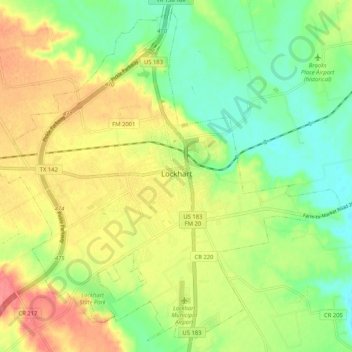
Nome: Mapa topográfico Lockhart, altitude, relevo.
Local: Lockhart, Caldwell County, Texas, 78644, United States (29.84064 -97.72832 29.92447 -97.62464)
Altitude média: 156 m
Altitude mínima: 125 m
Altitude máxima: 193 m
Obrigado por apoiar este site ❤️
Faça uma doação
Faça uma doação
Outros mapas topográficos
Clique em um mapa para visualizar sua topografia, sua altitude e seu relevo.
Lockhart State Park
United States > Texas > Caldwell County > Lockhart
The park features roughly four miles of designated trails that cover a wide range of environments. In addition to multiple short, shade covered trails along the creek in a riparian zone, a network of natural trails traversing multiple hillsides and ravines is located on the backside of the park. A moderate…
Altitude média: 165 m
Obrigado por apoiar este site ❤️
Faça uma doação
Faça uma doação