
Mapa topográfico Trunstadt
Mapa interativo
Clique no mapa para exibir a altitude.
Sobre este mapa
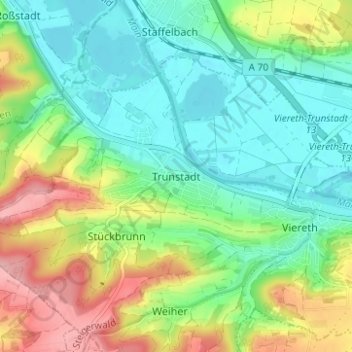
Nome: Mapa topográfico Trunstadt, altitude, relevo.
Altitude média: 274 m
Altitude mínima: 224 m
Altitude máxima: 370 m
Outros mapas topográficos
Clique em um mapa para visualizar sua topografia, sua altitude e seu relevo.
Viereth
Deutschland > Bayern > Landkreis Bamberg > Viereth-Trunstadt
Viereth, Viereth-Trunstadt, Landkreis Bamberg, Bayern, 96191, Deutschland
Altitude média: 270 m