
Mapa topográfico Maasmechelen
Mapa interativo
Clique no mapa para exibir a altitude.
Sobre este mapa
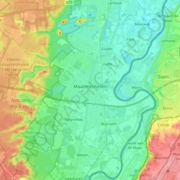
Nome: Mapa topográfico Maasmechelen, altitude, relevo.
Local: Maasmechelen, Tongeren, Limburg, Belgium (50.91037 5.59532 51.01227 5.76767)
Altitude média: 57 m
Altitude mínima: 28 m
Altitude máxima: 119 m
The plateau of Campine was built up during the ice age with deposits of sand and other material that the Meuse river had eroded in the upstream Ardennes region. The higher elevation and the proximity of fertile river clay made this location an attractive one for the prehistoric tribes who established themselves here in the 2nd millennium BC and for the Celtic peoples who moved in the area in the 1st millennium BC.
Outros mapas topográficos
Clique em um mapa para visualizar sua topografia, sua altitude e seu relevo.
Waltwilder
Belgium > Limburg > Tongeren > Bilzen
Waltwilder, Bilzen, Tongeren, Limburg, Flanders, Belgium
Altitude média: 75 m
Veurs
Belgium > Limburg > Tongeren > Sint-Martens-Voeren
Veurs, Sint-Martens-Voeren, Voeren, Tongeren, Limburg, Flanders, 3790, Belgium
Altitude média: 213 m
Eigenbilzen
Belgium > Limburg > Tongeren > Bilzen > Eigenbilzen
Eigenbilzen, Bilzen, Tongeren, Limburg, Flanders, Belgium
Altitude média: 75 m
Rullekoven
Belgium > Limburg > Tongeren > Borgloon > Kerniel > Rullekoven
Rullekoven, Kerniel, Borgloon, Tongeren, Limburg, Flanders, 3840, Belgium
Altitude média: 84 m