
Mapa topográfico Saint-Jean-Geest
Mapa interativo
Clique no mapa para exibir a altitude.
Sobre este mapa
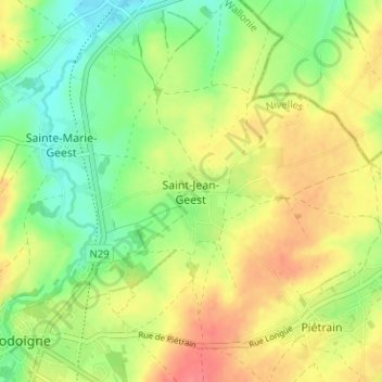
Nome: Mapa topográfico Saint-Jean-Geest, altitude, relevo.
Altitude média: 82 m
Altitude mínima: 53 m
Altitude máxima: 114 m
Outros mapas topográficos
Clique em um mapa para visualizar sua topografia, sua altitude e seu relevo.
Piétrain
Belgique > Brabant wallon > Nivelles > Jodoigne
Piétrain, Jodoigne, Nivelles, Brabant wallon, Wallonie, Belgique
Altitude média: 90 m
Arbre de la liberté
Belgique > Brabant wallon > Nivelles > Jodoigne
Arbre de la liberté, Grand'Place, Les Rendanges, Jodoigne, Nivelles, Brabant wallon, Wallonie, 1370, Belgique
Altitude média: 85 m
Gobertange
Belgique > Brabant wallon > Nivelles > Jodoigne
Gobertange, Jodoigne, Nivelles, Brabant wallon, Wallonie, 1370, Belgique
Altitude média: 98 m
Sainte-Marie-Geest
Belgique > Brabant wallon > Nivelles > Jodoigne > Sainte-Marie-Geest
Sainte-Marie-Geest, Jodoigne, Nivelles, Brabant wallon, Wallonie, 1370, Belgique
Altitude média: 82 m