
Mapa topográfico Mount Greylock
Mapa interativo
Clique no mapa para exibir a altitude.
Sobre este mapa
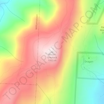
Nome: Mapa topográfico Mount Greylock, altitude, relevo.
Altitude média: 746 m
Altitude mínima: 386 m
Altitude máxima: 1.062 m
Geographically, Mount Greylock is part of an 11-mile-long (18 km) by 4+1⁄2-mile-wide (7 km) island-like range that runs north-south between the Hoosac Range to the east, the Green Mountains to the north, the Berkshires to both the south and east, and the Taconic Mountains to the west with which it is geologically associated; all ranges are associated with the Appalachian mountain chain. The summit of Mount Greylock is located in Adams, Massachusetts, but the mountain also extends into Cheshire, Lanesborough, New Ashford, North Adams and Williamstown. The range includes peaks with elevation less than Greylock, such as Saddle Ball Mountain and Mount Fitch.
Outros mapas topográficos
Clique em um mapa para visualizar sua topografia, sua altitude e seu relevo.
Maple Grove
United States > Massachusetts > Berkshire County > Adams
Maple Grove, Adams, Berkshire County, Massachusetts, 01220, United States
Altitude média: 342 m