
Mapa topográfico Long Pond
Mapa interativo
Clique no mapa para exibir a altitude.
Long Pond
Long Pond is named after the unique wetland topography formed by the Tunkhannock Creek. Within the Long Pond community, public access lands are owned and protected by The Bethlehem Authority, Nature Conservancy, Wildlands Conservancy County of Monroe Open Space Program, , PA Game Commission and PA Department of Forest and Waters. Long Pond is home to many species of unique plants and animals.
Sobre este mapa
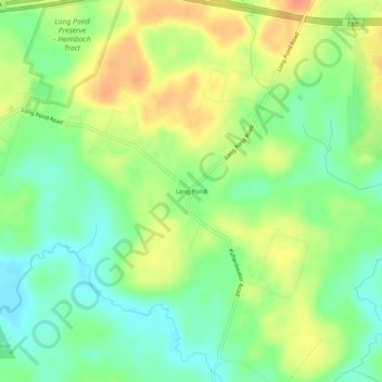
Nome: Mapa topográfico Long Pond, altitude, relevo.
Altitude média: 571 m
Altitude mínima: 550 m
Altitude máxima: 596 m
Outros mapas topográficos
Clique em um mapa para visualizar sua topografia, sua altitude e seu relevo.
Indian Mountain Lake
United States > Pennsylvania > Monroe County > Tunkhannock Township > Indian Mountain Lake
Altitude média: 506 m