
Mapa topográfico Davenport
Mapa interativo
Clique no mapa para exibir a altitude.
Sobre este mapa
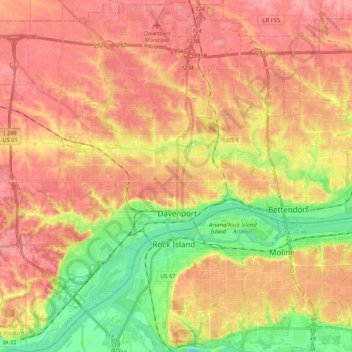
Nome: Mapa topográfico Davenport, altitude, relevo.
Local: Davenport, Scott County, Iowa, United States (41.46063 -90.68793 41.62029 -90.49082)
Altitude média: 205 m
Altitude mínima: 157 m
Altitude máxima: 237 m
Outros mapas topográficos
Clique em um mapa para visualizar sua topografia, sua altitude e seu relevo.
Park View
United States > Iowa > Scott County
Park View, Scott County, Iowa, United States
Altitude média: 235 m
Buffalo
United States > Iowa > Scott County
Buffalo, Buffalo Township, Scott County, Iowa, 52728, United States
Altitude média: 205 m
Sheridan Township
United States > Iowa > Scott County
Sheridan Township, Scott County, Iowa, 52748, United States
Altitude média: 231 m
Bettendorf
United States > Iowa > Scott County > Pleasant Valley Township
Bettendorf, Pleasant Valley Township, Scott County, Iowa, 52722, United States
Altitude média: 207 m
Pleasant Valley Township
United States > Iowa > Scott County
Pleasant Valley Township, Scott County, Iowa, United States
Altitude média: 198 m
Le Claire
United States > Iowa > Scott County
Le Claire, Le Claire Township, Scott County, Iowa, United States
Altitude média: 200 m
Walcott
United States > Iowa > Scott County > Walcott
Walcott, Blue Grass Township, Scott County, Iowa, United States
Altitude média: 227 m
Eldridge
United States > Iowa > Scott County
Eldridge, Sheridan Township, Scott County, Iowa, 52748, United States
Altitude média: 234 m
Davenport
United States > Iowa > Scott County > Davenport
Davenport, Scott County, Iowa, 52801, United States
Altitude média: 212 m
Blue Grass
United States > Iowa > Scott County
Blue Grass, Blue Grass Township, Scott County, Iowa, United States
Altitude média: 239 m
Long Grove
United States > Iowa > Scott County
Long Grove, Scott County, Iowa, United States
Altitude média: 235 m