
Mapa topográfico Ehenfeld
Mapa interativo
Clique no mapa para exibir a altitude.
Sobre este mapa
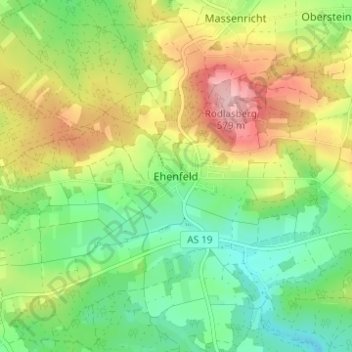
Nome: Mapa topográfico Ehenfeld, altitude, relevo.
Altitude média: 478 m
Altitude mínima: 408 m
Altitude máxima: 581 m
Outros mapas topográficos
Clique em um mapa para visualizar sua topografia, sua altitude e seu relevo.
92242
Deutschland > Bayern > Landkreis Amberg-Sulzbach > Hirschau
92242, Hirschau, Landkreis Amberg-Sulzbach, Bayern, Deutschland
Altitude média: 430 m
Massenricht
Deutschland > Bayern > Landkreis Amberg-Sulzbach > Hirschau
Massenricht, Hirschau, Landkreis Amberg-Sulzbach, Bayern, 92242, Deutschland
Altitude média: 477 m