
Obrigado por apoiar este site ❤️
Faça uma doação
Faça uma doação
Mapa topográfico Navalagunda
Clique no mapa para exibir a altitude.
Obrigado por apoiar este site ❤️
Faça uma doação
Faça uma doação
Navalagunda
Navalgund is located at 15°34′N 75°22′E / 15.57°N 75.37°E / 15.57; 75.37. It has an average elevation of 578 metres (1896 feet). It is situated 35 km from Hubli and is famous as the birth place of 'Jamkhanas', the floor covering woven using cotton ropes, a kind of flat & thin carpet. It is famous for the Holi festival. The world famous Ramling Kamanna and the famous Naglinga Swamy temple are in Navalgund, as well as the famous Nilamma Tank
Obrigado por apoiar este site ❤️
Faça uma doação
Faça uma doação
Sobre este mapa
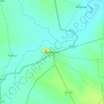
Nome: Mapa topográfico Navalagunda, altitude, relevo.
Altitude média: 579 m
Altitude mínima: 564 m
Altitude máxima: 644 m
Obrigado por apoiar este site ❤️
Faça uma doação
Faça uma doação