
Faça uma doação
Mapa topográfico St. Bonifacius
Clique no mapa para exibir a altitude.
Faça uma doação
Sobre este mapa
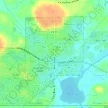
Nome: Mapa topográfico St. Bonifacius, altitude, relevo.
Altitude média: 295 m
Altitude mínima: 281 m
Altitude máxima: 320 m
Faça uma doação
Outros mapas topográficos
Clique em um mapa para visualizar sua topografia, sua altitude e seu relevo.
Minneapolis
United States > Minnesota > Hennepin County > Minneapolis
A 1959 report by the U.S. Soil Conservation Service listed Minneapolis's elevation as 830 feet (250 m). The city's lowest elevation of 687 feet (209 m) above sea level is near where Minnehaha Creek meets the Mississippi River. Sources disagree on the exact location and elevation of the city's highest point,…
Altitude média: 271 m
Minnehaha Falls
United States > Minnesota > Hennepin County > Minneapolis
Fortunately for the generations to come, in 1883 the state legislature created the Minneapolis Board of Park Commissioners. The board began by acquiring park land near today's downtown Minneapolis. Their choice to hire noted landscape architect Horace Cleveland was fortunate. Cleveland was hired by the Board…
Altitude média: 249 m
Faça uma doação
Bloomington
United States > Minnesota > Hennepin County > Bloomington > Bloomington
Altitude média: 253 m
Maple Grove
United States > Minnesota > Hennepin County > Maple Grove > Maple Grove
Altitude média: 280 m
Faça uma doação
Saint Louis Park
United States > Minnesota > Hennepin County > Saint Louis Park > Saint Louis Park
Altitude média: 274 m
Golden Valley
United States > Minnesota > Hennepin County > Golden Valley > Golden Valley
Altitude média: 276 m
Faça uma doação